Ljuta
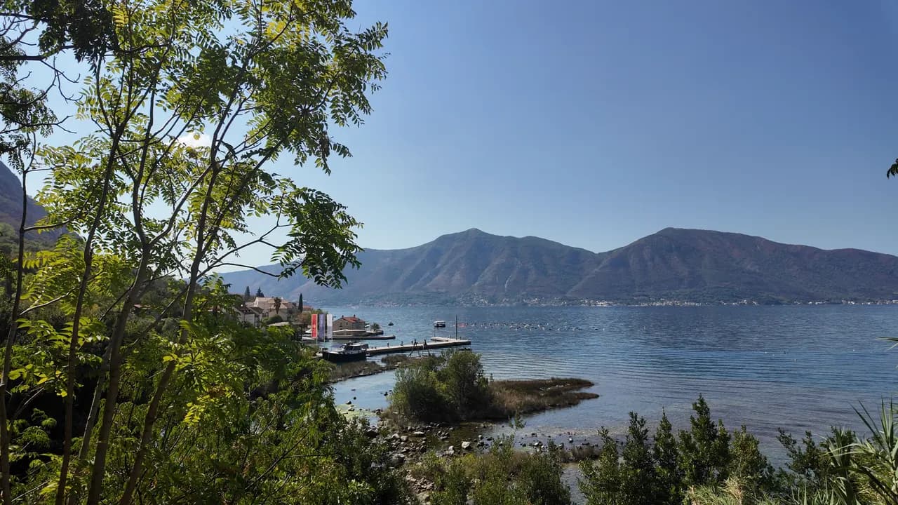
Betonska kupališna platforma na obalskom putu u Dobroti, kraj ušća rijeke duge 200 metara koja izvire iz planine na 7 °C — najhladnije kupanje u zalivu.
Naša ocjena
Ljuta je kupanje za one koji vole taj šok: betonska platforma uz obalski put, odmah duboka voda, i, 500 m sjevernije, ušće Ljute, jedne od najkraćih rijeka u Crnoj Gori, koja teče oko 200 m od svog krškog izvora do mora na temperaturi od oko 7 °C i hladi zaliv oko sebe. Ništa ovdje nije uređeno i ništa ne košta; autobus Plave linije staje na samom ulazu, a stare vodenice kod izvora razlog su da ostanete na ručku.
- plivanje
- mir
Ljuta u činjenicama
Obala
Sadržaji
Pristup
Činjenice provjerene 28. septembar 2026. · Dužina: Not measured: OpenStreetMap maps the platform as a single node (10975260927, surface concrete); a concrete bathing platform of a few tens of metres — an order of magnitude, not a survey · Još 11 podataka treba provjeriti na licu mjesta
Ljuta u slikama
Fotografije i snimci: Montenegro.com, slobodni za korišćenje pod licencom CC BY 4.0. Naši snimci su iz septembar 2026..
Mapa
Kako doći
6.2 km
Kotor
9.0 km
Tivat airport
19 km
Herceg Novi
Rastojanja vazdušnom linijom — crnogorski putevi su planinski, pa je vožnja duža.
- AutobusomKotor local bus (Blue Line) — the Ljuta stop, with a shelter, on the shore road
- Autom7 km from Kotor Old Town along the Dobrota shore road; there is no beach car park — park at Stari Mlini by the river, 500 m north
- 1 min pješkeravno — The platform is on the shore side of the M-1 at the Ljuta bus stop
Danas na plaži Ljuta
Orijentacija je izračunata iz OpenStreetMap linije obale, pa se „prema obali“ i „s kopna“ odnose na ovu obalu, a ne na region. Prognoza: Open-Meteo
Voda i priznanja
Najbliža zvanična mjerna stanica
Odlična
Posljednji zvanični uzorak 28. septembar 2026.: Odlična
Monitoring nema mjerno mjesto na plaži Ljuta. Ovaj rezultat je sa stanice Orahovac 01, 1.2 km dalje, na lokaciji Orahovac — isto more, ali ne i ova obala.
More 20.4 °C u trenutku uzorkovanja
10 od 10 uzoraka ocijenjeno odlično u sezoni 2026
Zvanični rezultat JP Morsko dobro, mjerna stanica Orahovac 01
Najhladnije kupanje u zalivu: rijeka Ljuta stiže do mora na oko 7 °C, 500 m sjeverno od platforme. Nema stanice Morskog Dobra na Ljutoj
Nema priznanja koje možemo navesti za ovu plažu. I to je informacija.
Znajte prije kupanja
- Rijeka utiče u more na oko 7 °C, a voda blizu ušća je primjetno hladnija od ostatka zaliva — hladni šok je stvaran čak i u avgustu; prvo umočite ruku
- Ulazak je sa betonske platforme direktno u duboku vodu: nema plaže, nema blagog ulaska, nema spasioca
- Jadranska magistrala (M-1) prolazi neposredno iza platforme, a autobuska stanica se nalazi na njoj
- Duž ove obale se pružaju plutajuće linije uzgajališta dagnji — klonite ih se
Kad je more toplo
Najtoplije je bilo 27.8 °C, 31. avgust 2026., a najhladnije 20.4 °C, 28. septembar 2026.. Svaka tačka je stvarni izlazak na teren, sa temperaturom izmjerenom na licu mjesta, a ne mjesečni prosjek prepisan sa strane.
Prikaži svih 10 uzorkovanja
| Uzorkovano | More | Ocjena |
|---|---|---|
| 28. septembar 2026. | 20.4 °C | Odlična |
| 14. septembar 2026. | 25.2 °C | Odlična |
| 31. avgust 2026. | 27.8 °C | Odlična |
| 17. avgust 2026. | 25.9 °C | Odlična |
| 3. avgust 2026. | 24.8 °C | Odlična |
| 20. jul 2026. | 27.5 °C | Odlična |
| 6. jul 2026. | 21.2 °C | Odlična |
| 22. jun 2026. | 24.6 °C | Odlična |
| 8. jun 2026. | 24.1 °C | Odlična |
| 25. maj 2026. | 21.0 °C | Odlična |
Zvanični rezultat JP Morsko dobro, mjerna stanica Orahovac 01
Kategorija kupališta
Obala se izdaje u zakup lokacija po lokacija. Ljuta je raspisana kroz 3 lokacije na oko 162 m obale, svaka sa zvaničnom kategorijom.
| Kategorija | Lokacija | Obala |
|---|---|---|
| Javno-porodično | 3 | 162 m |
Ukupno oko 900 m². Ovo je ono što je dato u zakup, a ne ono što smo zatekli: broj ležaljki, sanitarnih čvorova i tuševa po lokaciji utvrđuje se potpisanim ugovorom, koji se ne objavljuje. Tenderi JP Morsko dobro
Plaže u blizini



Ljuta i susjedne plaže
Istih devet podataka za plaže do kojih možete stići istog dana. Podebljano znači da se razlikuje od ove.
| Podatak |  Ljutaova plaža Ljutaova plaža |  Orahovac1.2 km Orahovac1.2 km |  Stoliv4.5 km Stoliv4.5 km |  Lipci8.9 km Lipci8.9 km |
|---|---|---|---|---|
| Podloga | betonski platoi | šljunak — razlikuje se | betonski platoi | šljunak — razlikuje se |
| Ulazak u more | strm | umjeren — razlikuje se | strm | kamenit — razlikuje se |
| Dubina | duboko odmah uz obalu | brzo postaje duboko — razlikuje se | duboko odmah uz obalu | brzo postaje duboko — razlikuje se |
| Hlad | nema | prirodni — razlikuje se | nema | nema |
| Karakter | divlja | divlja | divlja | divlja |
| Dužina | 10–30 m | 150 m — razlikuje se | 100 m — razlikuje se | 20–50 m — razlikuje se |
| Posljednji uzorak | —nema zvaničnog mjernog mjesta | Odlična — razlikuje se | Odlična — razlikuje se | —nema zvaničnog mjernog mjesta |
| Gužva | mir | mir | mir | mir |
| Kako doći | automobilom | automobilom | automobilom | automobilom |
Smještaj blizu plaže Ljuta — Kotor, 6.2 km dalje
Sav smještaj u mjestu Kotor →

Pitanja
- Gdje se ljudi kupaju na Ljutoj?
- Sa betonske kupališne platforme na strani M-1 okrenutoj moru, kod autobuske stanice Ljuta, koju OpenStreetMap označava kao „Ljuta Beach“, i sa malih šljunkovitih uvala južno od sela.
- Koliko je voda hladna?
- Rijeka Ljuta stiže do mora na oko 7 °C, a zaliv oko ušća je primjetno hladniji nego drugdje; otvoreni dio zaliva u avgustu dostigne oko 25 °C. Savjet centralne stranice je jednostavan: prvo umočite ruku u vodu.
- Ima li gdje da se parkira?
- Ne kod same platforme. Parkirajte kod Starih Mlina, restorana kod starih vodenica na rijeci 500 m sjevernije, ili dođite autobusom Plave linije iz Kotora, udaljenog 7 km.
Izvori
- montenegro.com — Ljuta hub (/cities/ljuta) and its source notes (OSM Ljuta Beach node, the Blue line stop, Stari Mlini, the river way and the mills’ listing)
- OpenStreetMap — node 10975260927 "Ljuta Beach" (surface=concrete), bus stop node 11171754614 "Ljuta" (Blue line, shelter), M-1 way 1097670961, river way 240236187
- montenegro.com — Orahovac hub (the Ljuta as the spring at the southern edge of Orahovac; Ljuta 1.2 km from Orahovac)