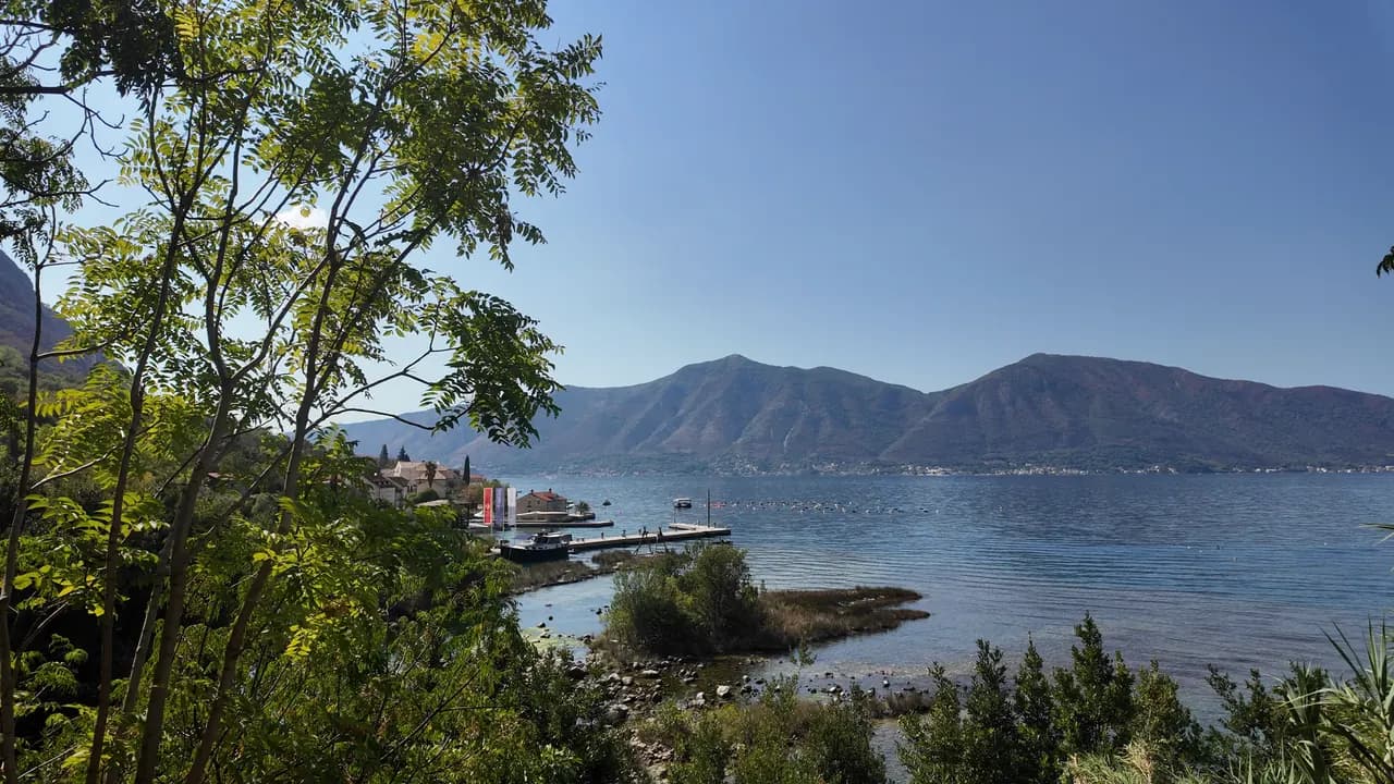
Ljuta
Eine Beton-Badeplattform an der Küstenstraße von Dobrota neben der Mündung eines 200 Meter langen Flusses, der mit 7 °C aus dem Berg kommt — das kälteste Bad in der Bucht.
Unser Urteil
Ljuta ist ein Bad für Menschen, die den Schock mögen: eine Betonplattform an der Küstenstraße, sofort tiefes Wasser, und 500 m nördlich die Mündung der Ljuta, eines der kürzesten Flüsse Montenegros, der auf rund 200 m von seiner Karstquelle bis zum Meer bei etwa 7 °C verläuft und die Bucht um sie herum abkühlt. Nichts ist bewirtschaftet und nichts kostet etwas; der Bus der Blue Line hält direkt davor, und die alten Mühlen an der Quelle sind der Grund, zum Mittagessen zu bleiben.
- Schwimmen
- Ruhe
Ljuta in Fakten
Das Ufer
Ausstattung
Anfahrt
Fakten geprüft am 28. September 2026 · Länge: Not measured: OpenStreetMap maps the platform as a single node (10975260927, surface concrete); a concrete bathing platform of a few tens of metres — an order of magnitude, not a survey · 11 weitere Angaben müssen wir vor Ort prüfen
Ljuta in Bildern
Fotos und Filmaufnahmen von Montenegro.com, frei verwendbar unter CC BY 4.0. Unsere Aufnahmen stammen aus September 2026.
Karte
Anfahrt
6.2 km
Kotor
9.0 km
Tivat airport
19 km
Herceg Novi
Luftlinie — Montenegros Straßen sind Bergstraßen, die Fahrt ist also länger.
- Mit dem BusKotor local bus (Blue Line) — the Ljuta stop, with a shelter, on the shore road
- Mit dem Auto7 km from Kotor Old Town along the Dobrota shore road; there is no beach car park — park at Stari Mlini by the river, 500 m north
- 1 Min. zu Fußeben — The platform is on the shore side of the M-1 at the Ljuta bus stop
Heute an Ljuta
Die Ausrichtung ist aus der OpenStreetMap-Küstenlinie berechnet, auflandig und ablandig meinen also dieses Ufer und nicht die Region. Vorhersage von Open-Meteo
Wasser und Auszeichnungen
Nächstgelegene amtliche Messstelle
Ausgezeichnet
Letzte amtliche Probe 28. September 2026: Ausgezeichnet
Das Monitoring hat an Ljuta keine Messstelle. Dieser Wert stammt von der Messstelle Orahovac 01, 1.2 km entfernt bei Orahovac — dasselbe Gewässer, aber nicht dieses Ufer.
Wasser 20.4 °C bei der Probenahme
10 von 10 Proben ausgezeichnet in der Saison 2026
Offizielles Ergebnis von JP Morsko dobro, Messstelle Orahovac 01
Das kälteste Bad in der Bucht: Der Fluss Ljuta erreicht das Meer 500 m nördlich der Plattform mit etwa 7 °C. Keine Morsko-Dobro-Station in Ljuta
Keine Auszeichnung, die wir für diesen Strand belegen können. Auch das ist eine Information.
Vor dem Baden wissen
- Der Fluss mündet mit etwa 7 °C ins Meer, und das Wasser nahe der Mündung ist merklich kälter als der Rest der Bucht — Kälteschock ist auch im August real; zuerst eine Hand hineinhalten
- Der Einstieg erfolgt von einer Betonplattform direkt ins tiefe Wasser: kein Strand, kein sanfter Einstieg, kein Rettungsschwimmer
- Die Jadranska magistrala (M-1) verläuft direkt hinter der Plattform, und die Bushaltestelle liegt an ihr
- Entlang dieser Küste liegen Schwimmleinen von Muschelfarmen im Wasser — ihnen fernbleiben
Wann das Wasser warm ist
Ljuta war am wärmsten mit 27.8 °C am 31. August 2026 und am kältesten mit 20.4 °C am 28. September 2026. Jeder Punkt ist eine echte Messfahrt mit vor Ort abgelesener Temperatur, kein anderswo abgeschriebener Monatsmittelwert.
Alle 10 Messungen ansehen
| Gemessen | Wasser | Ergebnis |
|---|---|---|
| 28. September 2026 | 20.4 °C | Ausgezeichnet |
| 14. September 2026 | 25.2 °C | Ausgezeichnet |
| 31. August 2026 | 27.8 °C | Ausgezeichnet |
| 17. August 2026 | 25.9 °C | Ausgezeichnet |
| 3. August 2026 | 24.8 °C | Ausgezeichnet |
| 20. Juli 2026 | 27.5 °C | Ausgezeichnet |
| 6. Juli 2026 | 21.2 °C | Ausgezeichnet |
| 22. Juni 2026 | 24.6 °C | Ausgezeichnet |
| 8. Juni 2026 | 24.1 °C | Ausgezeichnet |
| 25. Mai 2026 | 21.0 °C | Ausgezeichnet |
Offizielles Ergebnis von JP Morsko dobro, Messstelle Orahovac 01
Konzessioniert als
Der Staat verpachtet diese Küste Los für Los. Ljuta ist in 3 Lose mit rund 162 m Uferlänge ausgeschrieben, jedes mit einer amtlichen Kategorie.
| Kategorie | Lose | Ufer |
|---|---|---|
| Familienbad | 3 | 162 m |
Zusammen etwa 900 m². Das ist das Konzessionierte, nicht das Gesehene: Zahl der Liegen, Toiletten und Duschen je Los steht im unterzeichneten Pachtvertrag, der nicht veröffentlicht wird. Ausschreibungen von JP Morsko dobro
Strände in der Nähe



Ljuta und seine Nachbarn
Dieselben neun Angaben für die Strände, die Sie am selben Tag erreichen. Fett bedeutet: anders als hier.
| Angabe |  Ljutadieser Strand Ljutadieser Strand |  Orahovac1.2 km Orahovac1.2 km |  Stoliv4.5 km Stoliv4.5 km |  Lipci8.9 km Lipci8.9 km |
|---|---|---|---|---|
| Untergrund | Betonplattformen | Kies — weicht ab | Betonplattformen | Kies — weicht ab |
| Einstieg | steil | mäßig — weicht ab | steil | felsig — weicht ab |
| Tiefe | tief ab dem Ufer | wird schnell tief — weicht ab | tief ab dem Ufer | wird schnell tief — weicht ab |
| Schatten | keiner | natürlich — weicht ab | keiner | keiner |
| Charakter | wild | wild | wild | wild |
| Länge | 10–30 m | 150 m — weicht ab | 100 m — weicht ab | 20–50 m — weicht ab |
| Letzte Messung | —keine amtliche Messstelle | Ausgezeichnet — weicht ab | Ausgezeichnet — weicht ab | —keine amtliche Messstelle |
| Andrang | Ruhe | Ruhe | Ruhe | Ruhe |
| Anfahrt | mit dem Auto | mit dem Auto | mit dem Auto | mit dem Auto |
Übernachten in der Nähe von Ljuta — Kotor, 6.2 km entfernt
Alle Unterkünfte in Kotor →

Fragen
- Wo schwimmen die Menschen in Ljuta?
- Von der Beton-Badeplattform auf der Uferseite der M-1 an der Bushaltestelle Ljuta, von OpenStreetMap als „Ljuta Beach“ verzeichnet, sowie von den kleinen Kiesbuchten südlich des Dorfes.
- Wie kalt ist das Wasser?
- Der Fluss Ljuta erreicht das Meer mit etwa 7 °C, und die Bucht um die Mündung herum ist merklich kälter als anderswo; die offene Bucht erreicht im August etwa 25 °C. Der Rat des Hubs ist einfach: zuerst eine Hand ins Wasser halten.
- Gibt es einen Parkplatz?
- Nicht an der Plattform. Parken Sie bei Stari Mlini, dem Restaurant an den alten Mühlen am Fluss, 500 m nördlich, oder kommen Sie mit dem Bus der Blue Line aus Kotor, 7 km entfernt.
Quellen
- montenegro.com — Ljuta hub (/cities/ljuta) and its source notes (OSM Ljuta Beach node, the Blue line stop, Stari Mlini, the river way and the mills’ listing)
- OpenStreetMap — node 10975260927 "Ljuta Beach" (surface=concrete), bus stop node 11171754614 "Ljuta" (Blue line, shelter), M-1 way 1097670961, river way 240236187
- montenegro.com — Orahovac hub (the Ljuta as the spring at the southern edge of Orahovac; Ljuta 1.2 km from Orahovac)