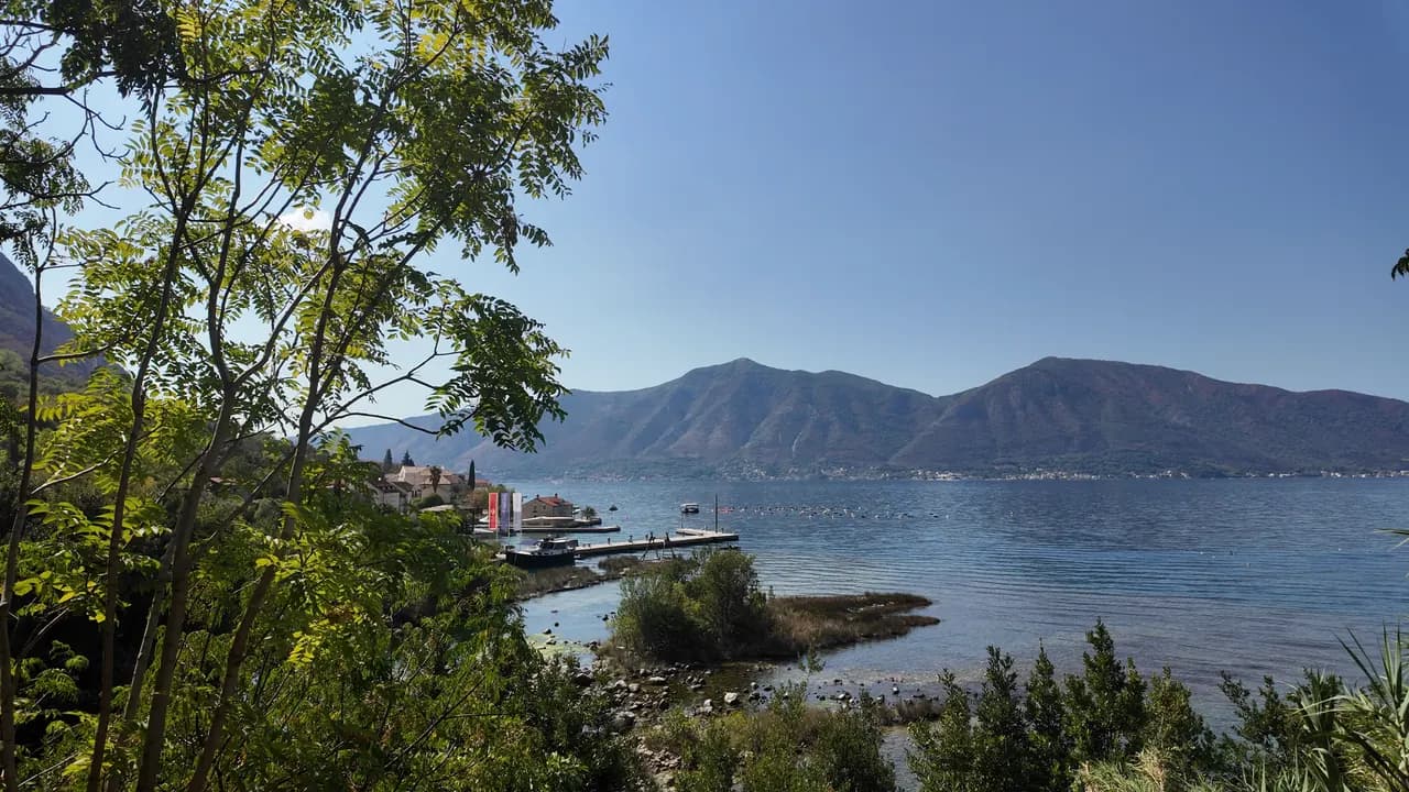
Ljuta
Una plataforma de baño de hormigón en la carretera de la costa de Dobrota, junto a la desembocadura de un río de 200 metros que sale de la montaña a 7 °C — el baño más frío de la bahía.
Nuestro veredicto
Ljuta es un baño para quienes disfrutan del impacto del frío: una plataforma de hormigón junto a la carretera de la costa, agua profunda de inmediato, y, 500 m al norte, la desembocadura del Ljuta, uno de los ríos más cortos de Montenegro, que recorre unos 200 m desde su manantial kárstico hasta el mar a unos 7 °C y enfría la bahía a su alrededor. Nada está gestionado y nada cuesta; el autobús Blue Line para en la puerta, y los viejos molinos junto al manantial son motivo suficiente para quedarse a comer.
- nadar
- tranquilidad
Ljuta, en datos
La orilla
Servicios
Acceso
Datos verificados el 28 de septiembre de 2026 · Longitud: Not measured: OpenStreetMap maps the platform as a single node (10975260927, surface concrete); a concrete bathing platform of a few tens of metres — an order of magnitude, not a survey · Quedan 11 datos por comprobar sobre el terreno
Ljuta en imágenes
Fotografías y vídeos de Montenegro.com, libres de reutilizar bajo CC BY 4.0. Las nuestras se tomaron en septiembre de 2026.
Mapa
Cómo llegar
6.2 km
Kotor
9.0 km
Tivat airport
19 km
Herceg Novi
Distancias en línea recta — las carreteras de Montenegro son de montaña, así que el trayecto es más largo.
- En autobúsKotor local bus (Blue Line) — the Ljuta stop, with a shelter, on the shore road
- En coche7 km from Kotor Old Town along the Dobrota shore road; there is no beach car park — park at Stari Mlini by the river, 500 m north
- 1 min a piellano — The platform is on the shore side of the M-1 at the Ljuta bus stop
Hoy en Ljuta
La orientación se calcula a partir de la costa de OpenStreetMap, así que «hacia la playa» y «desde tierra» se refieren a esta orilla y no a la región. Previsión de Open-Meteo
Agua y galardones
Estación oficial más cercana
Excelente
Última muestra oficial 28 de septiembre de 2026: Excelente
El monitoreo no tiene punto de muestreo en Ljuta. Este resultado viene de la estación Orahovac 01, a 1.2 km, en Orahovac: la misma agua, pero no esta orilla.
Mar a 20.4 °C en el momento de la muestra
10 de 10 muestras excelentes en la temporada 2026
Resultado oficial de JP Morsko dobro, estación Orahovac 01
El baño más frío de la bahía: el río Ljuta llega al mar a unos 7 °C, 500 m al norte de la plataforma. No hay estación de Morsko Dobro en Ljuta
Ningún galardón que podamos citar para esta playa. La ausencia también es información.
Antes de bañarte
- El río entra en el mar a unos 7 °C y el agua cerca de la desembocadura es notablemente más fría que el resto de la bahía — el choque de frío es real incluso en agosto; meta primero la mano
- La entrada es desde una plataforma de hormigón a agua profunda: sin playa, sin entrada suave, sin socorrista
- La Jadranska magistrala (M-1) pasa justo detrás de la plataforma, y la parada de autobús está en ella
- En esta costa hay líneas de boyas de criaderos de mejillones mar adentro — manténgase alejado de ellas
Cuándo está templada el agua
Ljuta alcanzó su máximo, 27.8 °C, el 31 de agosto de 2026, y su mínimo, 20.4 °C, el 28 de septiembre de 2026. Cada punto es una toma de muestra real con la temperatura medida en el sitio, no un promedio mensual copiado de otra parte.
Ver los 10 muestreos
| Muestreo | Mar | Resultado |
|---|---|---|
| 28 de septiembre de 2026 | 20.4 °C | Excelente |
| 14 de septiembre de 2026 | 25.2 °C | Excelente |
| 31 de agosto de 2026 | 27.8 °C | Excelente |
| 17 de agosto de 2026 | 25.9 °C | Excelente |
| 3 de agosto de 2026 | 24.8 °C | Excelente |
| 20 de julio de 2026 | 27.5 °C | Excelente |
| 6 de julio de 2026 | 21.2 °C | Excelente |
| 22 de junio de 2026 | 24.6 °C | Excelente |
| 8 de junio de 2026 | 24.1 °C | Excelente |
| 25 de mayo de 2026 | 21.0 °C | Excelente |
Concesionada como
El Estado arrienda esta costa lote a lote. Ljuta sale a concurso como 3 lotes que suman unos 162 m de orilla, cada uno con una categoría oficial.
| Categoría | Lotes | Orilla |
|---|---|---|
| Baño familiar | 3 | 162 m |
Unos 900 m² en total. Esto es lo concesionado, no lo observado: el número de hamacas, aseos y duchas por lote se fija en el contrato firmado, que no se publica. Licitaciones de JP Morsko dobro
Playas cercanas



Ljuta y sus vecinas
Las mismas nueve medidas para las playas que puede alcanzar el mismo día. La negrita indica que difiere de esta.
| Medida |  Ljutaesta playa Ljutaesta playa |  Orahovac1.2 km Orahovac1.2 km |  Stoliv4.5 km Stoliv4.5 km |  Lipci8.9 km Lipci8.9 km |
|---|---|---|---|---|
| Superficie | plataformas de hormigón | guijarros — difiere | plataformas de hormigón | guijarros — difiere |
| Entrada | pronunciada | moderada — difiere | pronunciada | rocosa — difiere |
| Profundidad | profunda desde la orilla | gana fondo rápido — difiere | profunda desde la orilla | gana fondo rápido — difiere |
| Sombra | ninguna | natural — difiere | ninguna | ninguna |
| Carácter | salvaje | salvaje | salvaje | salvaje |
| Longitud | 10–30 m | 150 m — difiere | 100 m — difiere | 20–50 m — difiere |
| Última muestra | —sin punto de muestreo oficial | Excelente — difiere | Excelente — difiere | —sin punto de muestreo oficial |
| Afluencia | tranquilidad | tranquilidad | tranquilidad | tranquilidad |
| Cómo llegar | en coche | en coche | en coche | en coche |
Dónde dormir cerca de Ljuta — Kotor, a 6.2 km
Todos los alojamientos en Kotor →

Preguntas
- ¿Dónde nada la gente en Ljuta?
- Desde la plataforma de baño de hormigón en el lado de la orilla de la M-1, en la parada de autobús de Ljuta, cartografiada por OpenStreetMap como "Ljuta Beach", y desde las pequeñas calas de grava al sur del pueblo.
- ¿Qué tan fría está el agua?
- El río Ljuta llega al mar a unos 7 °C y la bahía alrededor de la desembocadura es notablemente más fría que en otras partes; la bahía abierta alcanza unos 25 °C en agosto. El consejo del resumen general es sencillo: meta primero la mano en el agua.
- ¿Hay dónde aparcar?
- No en la plataforma. Aparque en Stari Mlini, el restaurante de los viejos molinos en el río, 500 m al norte, o venga en el autobús Blue Line desde Kotor, a 7 km.
Fuentes
- montenegro.com — Ljuta hub (/cities/ljuta) and its source notes (OSM Ljuta Beach node, the Blue line stop, Stari Mlini, the river way and the mills’ listing)
- OpenStreetMap — node 10975260927 "Ljuta Beach" (surface=concrete), bus stop node 11171754614 "Ljuta" (Blue line, shelter), M-1 way 1097670961, river way 240236187
- montenegro.com — Orahovac hub (the Ljuta as the spring at the southern edge of Orahovac; Ljuta 1.2 km from Orahovac)