Ljuta
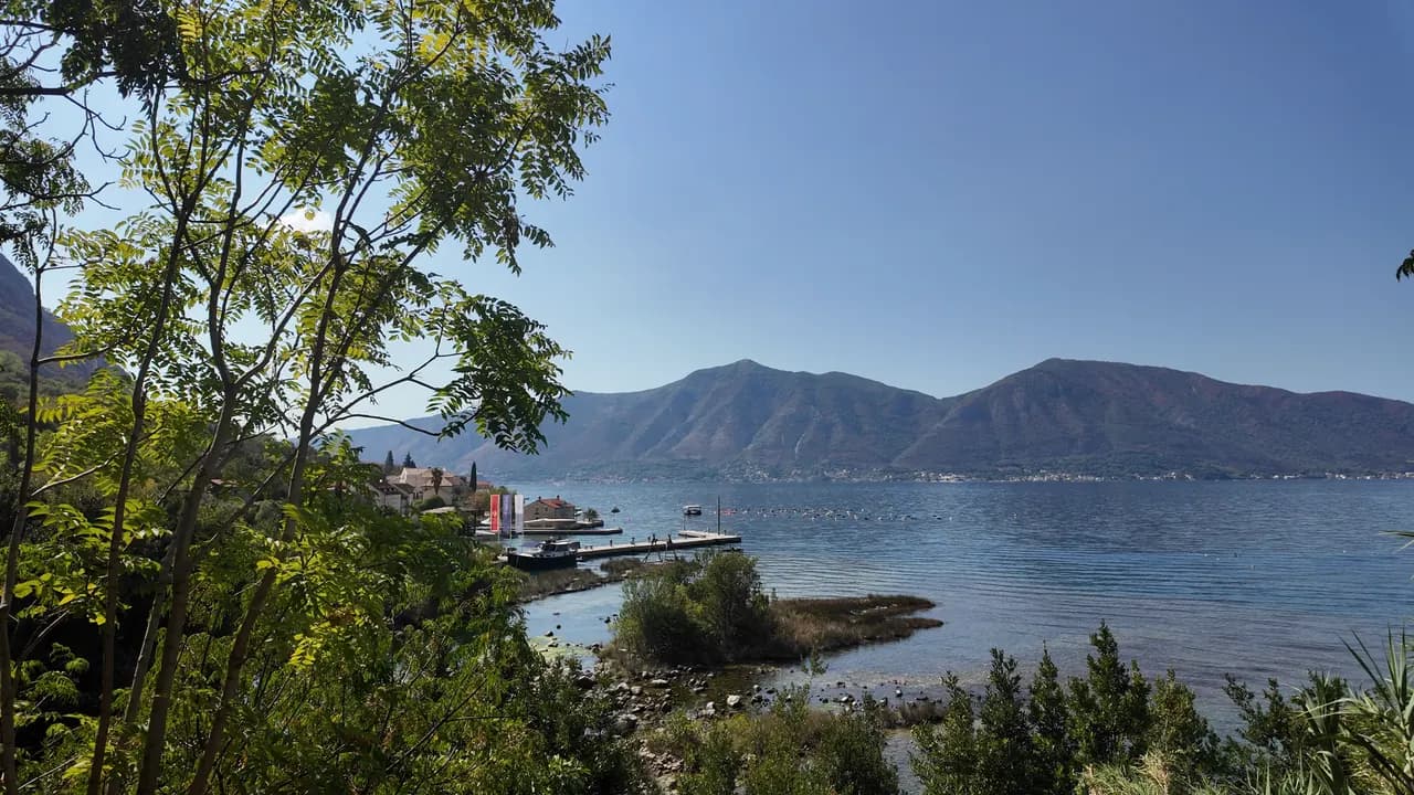
Une plateforme de baignade en béton sur la route littorale de Dobrota, à côté de l’embouchure d’une rivière de 200 mètres qui sort de la montagne à 7 °C — la baignade la plus froide de la baie.
Notre verdict
Ljuta est une baignade pour qui aime le choc : une plateforme en béton en bord de route, une eau profonde tout de suite, et, 500 m plus au nord, l’embouchure de la Ljuta, l’une des plus courtes rivières du Monténégro, qui parcourt environ 200 m depuis sa source karstique jusqu’à la mer à environ 7 °C et refroidit la baie alentour. Rien n’est aménagé et rien ne coûte ; le bus Blue Line s’arrête à la porte, et les vieux moulins près de la source sont une bonne raison de rester déjeuner.
- nage
- calme
Ljuta, en quelques repères
Le rivage
Équipements
Accès
Données vérifiées le 28 septembre 2026 · Longueur: Not measured: OpenStreetMap maps the platform as a single node (10975260927, surface concrete); a concrete bathing platform of a few tens of metres — an order of magnitude, not a survey · 11 points restent à vérifier sur place
Ljuta en images
Photographies et images de Montenegro.com, réutilisables sous licence CC BY 4.0. Les nôtres datent de septembre 2026.
Carte
Y aller
6.2 km
Kotor
9.0 km
Tivat airport
19 km
Herceg Novi
Distances à vol d'oiseau — les routes du Monténégro sont des routes de montagne, le trajet est donc plus long.
- En busKotor local bus (Blue Line) — the Ljuta stop, with a shelter, on the shore road
- En voiture7 km from Kotor Old Town along the Dobrota shore road; there is no beach car park — park at Stari Mlini by the river, 500 m north
- 1 min à piedplat — The platform is on the shore side of the M-1 at the Ljuta bus stop
Aujourd'hui à Ljuta
L’orientation est calculée depuis le trait de côte OpenStreetMap : « vers la plage » et « de la terre » désignent ce rivage, pas la région. Prévisions par Open-Meteo
Eau et labels
Station officielle la plus proche
Excellente
Dernier prélèvement officiel 28 septembre 2026 : Excellente
Le suivi n'a pas de point de prélèvement à Ljuta. Ce résultat vient de la station Orahovac 01, à 1.2 km, à Orahovac : la même eau, mais pas ce rivage.
Mer à 20.4 °C lors du prélèvement
10 prélèvements excellents sur 10 durant la saison 2026
Résultat officiel de JP Morsko dobro, station Orahovac 01
La baignade la plus froide de la baie : la rivière Ljuta atteint la mer à environ 7 °C, 500 m au nord de la plateforme. Aucune station Morsko Dobro à Ljuta
Aucun label que nous puissions citer pour cette plage. L'absence est aussi une information.
À savoir avant de se baigner
- La rivière se jette dans la mer à environ 7 °C et l’eau près de l’embouchure est nettement plus froide que le reste de la baie — le choc thermique est bien réel, même en août ; trempez d’abord une main
- L’entrée se fait depuis une plateforme en béton directement dans une eau profonde : pas de plage, pas d’entrée en pente douce, pas de maître-nageur
- La Jadranska magistrala (M-1) passe directement à l’arrière de la plateforme, et l’arrêt de bus s’y trouve
- Des lignes de flotteurs de moules s’étirent au large le long de cette côte — restez à l’écart
Quand l'eau est chaude
Ljuta a atteint son maximum, 27.8 °C, le 31 août 2026, et son minimum, 20.4 °C, le 28 septembre 2026. Chaque point est un prélèvement réel avec la température relevée sur place, et non une moyenne mensuelle recopiée ailleurs.
Voir les 10 prélèvements
| Prélevé | Mer | Résultat |
|---|---|---|
| 28 septembre 2026 | 20.4 °C | Excellente |
| 14 septembre 2026 | 25.2 °C | Excellente |
| 31 août 2026 | 27.8 °C | Excellente |
| 17 août 2026 | 25.9 °C | Excellente |
| 3 août 2026 | 24.8 °C | Excellente |
| 20 juillet 2026 | 27.5 °C | Excellente |
| 6 juillet 2026 | 21.2 °C | Excellente |
| 22 juin 2026 | 24.6 °C | Excellente |
| 8 juin 2026 | 24.1 °C | Excellente |
| 25 mai 2026 | 21.0 °C | Excellente |
Concédée comme
L’État loue ce littoral lot par lot. Ljuta est mise en adjudication en 3 lots couvrant environ 162 m de rivage, chacun avec une catégorie officielle.
| Catégorie | Lots | Rivage |
|---|---|---|
| Baignade familiale | 3 | 162 m |
Environ 900 m² au total. C’est ce qui est concédé, non ce que nous avons vu : le nombre de transats, de toilettes et de douches par lot est fixé dans le bail signé, qui n’est pas publié. Appels d’offres de JP Morsko dobro
Plages à proximité



Ljuta et ses voisines
Les mêmes neuf mesures pour les plages accessibles dans la journée. Le gras signale une différence avec celle-ci.
| Mesure |  Ljutacette plage Ljutacette plage |  Orahovac1.2 km Orahovac1.2 km |  Stoliv4.5 km Stoliv4.5 km |  Lipci8.9 km Lipci8.9 km |
|---|---|---|---|---|
| Sol | plateformes en béton | galets — diffère | plateformes en béton | galets — diffère |
| Entrée | abrupte | modérée — diffère | abrupte | rocheuse — diffère |
| Profondeur | profond dès le bord | profond rapidement — diffère | profond dès le bord | profond rapidement — diffère |
| Ombre | aucune | naturelle — diffère | aucune | aucune |
| Caractère | sauvage | sauvage | sauvage | sauvage |
| Longueur | 10–30 m | 150 m — diffère | 100 m — diffère | 20–50 m — diffère |
| Dernier prélèvement | —pas de point de prélèvement officiel | Excellente — diffère | Excellente — diffère | —pas de point de prélèvement officiel |
| Affluence | calme | calme | calme | calme |
| Accès | en voiture | en voiture | en voiture | en voiture |
Où dormir près de Ljuta — Kotor, à 6.2 km
Tous les hébergements à Kotor →

Questions
- Où se baigne-t-on à Ljuta ?
- Depuis la plateforme de baignade en béton, côté rivage de la M-1, à l’arrêt de bus de Ljuta, cartographiée par OpenStreetMap sous le nom « Ljuta Beach », ainsi que depuis les petites criques de gravier au sud du village.
- L’eau est-elle très froide ?
- La rivière Ljuta atteint la mer à environ 7 °C, et la baie autour de l’embouchure est nettement plus froide qu’ailleurs ; la baie ouverte atteint environ 25 °C en août. Le conseil de notre page est simple : trempez d’abord une main dans l’eau.
- Y a-t-il un endroit où se garer ?
- Pas à la plateforme. Garez-vous à Stari Mlini, le restaurant des vieux moulins sur la rivière, 500 m plus au nord, ou venez en bus Blue Line depuis Kotor, à 7 km.
Sources
- montenegro.com — Ljuta hub (/cities/ljuta) and its source notes (OSM Ljuta Beach node, the Blue line stop, Stari Mlini, the river way and the mills’ listing)
- OpenStreetMap — node 10975260927 "Ljuta Beach" (surface=concrete), bus stop node 11171754614 "Ljuta" (Blue line, shelter), M-1 way 1097670961, river way 240236187
- montenegro.com — Orahovac hub (the Ljuta as the spring at the southern edge of Orahovac; Ljuta 1.2 km from Orahovac)