
Stoliv
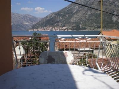
Aucune plage du tout — des plateformes et des pontons en béton sur le front de mer des capitaines de Donji Stoliv, face à Perast de l’autre côté d’une eau plate, avec les châtaigneraies du village d’en haut à l’arrière.
Notre verdict
Stoliv est honnête sur ce qu’il possède : le guide du village dit qu’il « n’a lui-même aucune plage, si bien que tout bain de soleil doit se faire sur les pontons », et c’est exactement la baignade : depuis le béton, dans une eau de baie profonde et calme, avec l’église du Nom de Marie dans le dos et Perast et ses îlots droit devant, de l’autre côté du détroit. C’est le terminus de la marche le long de la route côtière de la boka depuis Kotor, et l’étape de baignade la plus tranquille du littoral du Vrmac. Apportez tout ; le front de mer ne vend rien.
- nage
- calme
- photographie
Stoliv, en quelques repères
Le rivage
Équipements
Accès
Règles et caractère
Données vérifiées le 28 septembre 2026 · Longueur: Our 25 Best Beaches list — a nominal figure: OpenStreetMap maps no beach at Stoliv, only piers on the Donji Stoliv waterfront (ways 207657678, 207657679, 207657690); the swimming is off concrete platforms and pontoons · Équipements d'après OpenStreetMap contributors, ODbL · 6 points restent à vérifier sur place
Stoliv en images
Carte
La zone ombrée est la zone de baignade officielle de la station Stoliv 01 : la portion que JP Morsko dobro prélève réellement, et non le contour de la plage.
Y aller
7.3 km
Kotor
7.6 km
Tivat airport
14 km
Herceg Novi
Distances à vol d'oiseau — les routes du Monténégro sont des routes de montagne, le trajet est donc plus long.
- Sur la balade La route du rivage de la BokaLa route du rivage de la Boka
- En busKotor local bus along the Prčanj–Stoliv shore road (a morning run to Kotor)
- En voitureOn the Prčanj–Stoliv shore road, 4.9 km beyond Prčanj (about 9 minutes); park on the road under the campanile of the Name of Mary; the Kamenari–Lepetane ferry is 4.8 km further on
- 1 min à piedplat — Straight off the shore road onto the waterfront wall and the pontoons
Aujourd'hui à Stoliv
L’orientation est calculée depuis le trait de côte OpenStreetMap : « vers la plage » et « de la terre » désignent ce rivage, pas la région. Prévisions par Open-Meteo
Eau et labels
Excellente
Dernier prélèvement officiel 29 septembre 2026 : Excellente
Mer à 20.0 °C lors du prélèvement
7 prélèvements excellents sur 10 durant la saison 2026
Résultat officiel de JP Morsko dobro, station Stoliv 01
Une eau de baie calme et propre selon notre page de référence ; aucun résultat Morsko Dobro détenu pour Stoliv
Aucun label que nous puissions citer pour cette plage. L'absence est aussi une information.
À savoir avant de se baigner
- L’entrée se fait depuis des plateformes et des pontons en béton, directement dans une eau profonde : aucun rivage en pente douce pour les enfants, et les échelles ne sont pas toujours fiables
- Les pontons font aussi office de mouillages — de petits bateaux accostent là où les gens se baignent
- La route littorale passe directement derrière le muret du front de mer, et c’est là que l’on se gare
- Aucune ombre, eau, toilette ou nourriture sur le front de mer : apportez tout
Quand l'eau est chaude
Stoliv a atteint son maximum, 27.1 °C, le 1 septembre 2026, et son minimum, 20.0 °C, le 29 septembre 2026. Chaque point est un prélèvement réel avec la température relevée sur place, et non une moyenne mensuelle recopiée ailleurs.
Les points évidés sont les 3 prélèvements repassés sous « Excellent ».
Voir les 10 prélèvements
| Prélevé | Mer | Résultat |
|---|---|---|
| 29 septembre 2026 | 20.0 °C | Excellente |
| 15 septembre 2026 | 24.5 °C | Bonne |
| 1 septembre 2026 | 27.1 °C | Excellente |
| 21 août 2026 | 24.5 °C | Bonne |
| 4 août 2026 | 24.8 °C | Excellente |
| 21 juillet 2026 | 25.2 °C | Excellente |
| 7 juillet 2026 | 22.6 °C | Excellente |
| 25 juin 2026 | 22.6 °C | Suffisante |
| 9 juin 2026 | 21.1 °C | Excellente |
| 26 mai 2026 | 20.2 °C | Excellente |
Saison par saison
Stoliv a fait l'objet de 69 prélèvements depuis 2020 : 44 relevés excellents, 25 en dessous.
La chaleur qu'a atteinte l'eau, saison par saison. La moyenne ne porte que sur les prélèvements de juillet et août : une fenêtre fixe, pour qu'une année où les inspecteurs sont passés tôt ne paraisse pas froide.
Une poignée de saisons est un relevé, pas une tendance : ce que l'on voit ici est la dispersion normale de quelques mesures datées, non la preuve d'une mer qui se réchauffe ou se refroidit. Un point creux signale une saison où un prélèvement est passé sous « excellente ».
| Saison | Prélèvements | Excellente | En dessous | Moyenne juil.-août | Maximum |
|---|---|---|---|---|---|
| 2020 | 9 | 8 | 1 | 24.7 °C | 25.7 °C |
| 2021 | 10 | 6 | 4 | 26.1 °C | 27.9 °C |
| 2022 | 10 | 8 | 2 | 24.7 °C | 26.7 °C |
| 2023 | 10 | 4 | 6 | 25.1 °C | 26.4 °C |
| 2024 | 10 | 4 | 6 | 24.6 °C | 25.9 °C |
| 2025 | 10 | 7 | 3 | 24.4 °C | 25.7 °C |
| 2026en cours | 10 | 7 | 3 | 24.3 °C | 27.1 °C |
Concédée comme
L’État loue ce littoral lot par lot. Stoliv est mise en adjudication en 3 lots couvrant environ 196 m de rivage, chacun avec une catégorie officielle.
Également concédé ici : une plateforme d’amarrage dans l’eau devant la plage.
| Catégorie | Lots | Rivage |
|---|---|---|
| Baignade familiale | 2 | 109 m |
| Plage d’hôtel | 1 | 87 m |
Environ 2,018 m² au total. C’est ce qui est concédé, non ce que nous avons vu : le nombre de transats, de toilettes et de douches par lot est fixé dans le bail signé, qui n’est pas publié. Appels d’offres de JP Morsko dobro
Plages à proximité



Stoliv et ses voisines
Les mêmes neuf mesures pour les plages accessibles dans la journée. Le gras signale une différence avec celle-ci.
| Mesure | Stolivcette plage |  Bajova Kula2.4 km Bajova Kula2.4 km |  Ljuta4.5 km Ljuta4.5 km |  Lipci5.1 km Lipci5.1 km |
|---|---|---|---|---|
| Sol | plateformes en béton | galets — diffère | plateformes en béton | galets — diffère |
| Entrée | abrupte | modérée — diffère | abrupte | rocheuse — diffère |
| Profondeur | profond dès le bord | profond rapidement — diffère | profond dès le bord | profond rapidement — diffère |
| Ombre | aucune | naturelle — diffère | aucune | aucune |
| Caractère | sauvage | aménagée — diffère | sauvage | sauvage |
| Longueur | 100 m | 118 m | 10–30 m — diffère | 20–50 m — diffère |
| Dernier prélèvement | Excellente | Excellente | —pas de point de prélèvement officiel — diffère | —pas de point de prélèvement officiel — diffère |
| Affluence | calme | calme | calme | calme |
| Accès | en voiture | en voiture | en voiture | en voiture |
Dormir près de Stoliv
Tous les hébergements à Stoliv →

Questions
- Y a-t-il une plage à Stoliv ?
- Pas vraiment. Notre page de référence et le guide du village disent tous deux la même chose : de petites bandes de galets et des plateformes de baignade en béton le long du front de mer, avec des bains de soleil sur les pontons. OpenStreetMap y cartographie des jetées, mais aucune plage.
- Où se trouvent les châtaigniers ?
- Sur les pentes au-dessus du front de mer, autour de Gornji Stoliv, à 200–250 m d’altitude : de vieilles châtaigneraies avec des arbres dits vieux de plus de 400 ans, et une récolte encore célébrée localement à l’automne. Le sentier de pierre qui y monte prend environ 40 minutes.
- Peut-on marcher jusqu’ici depuis Kotor ?
- Oui : le corridor de la route côtière de la boka parcourt 10,2 km depuis Kotor, à travers Muo, Glavati et Prčanj, et se termine à Stoliv. Il existe un bus le matin pour revenir à Kotor.
Sources
- montenegro.com — Stoliv hub (/cities/stoliv) and its source notes: Discover Montenegro on the pontoons, the boka-shore-road corridor, the bus run to Kotor, Commons frame identification
- Our "25 Best Beaches in Montenegro" list, entry 24
- OpenStreetMap — pier ways 207657678, 207657679, 207657690, 207657685; village node 717410785 (Nominatim)