
Stoliv
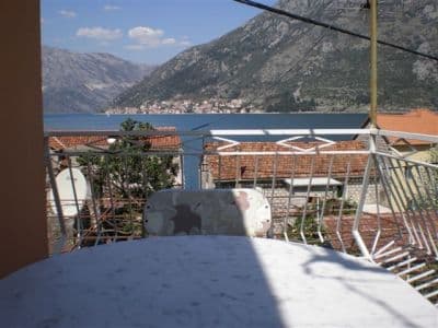
Ingen strand alls — betongplattformar och pontoner vid kaptenernas strandkant i Donji Stoliv, vänd mot Perast över spegelblankt vatten, med den övre byns kastanjeskogar bakom.
Vårt omdöme
Stoliv är ärlig om vad den har att erbjuda: byguiden säger att den "inte har några stränder alls, så allt solande måste ske på pontonerna", och det är badet — från betong, ner i djupt, lugnt bukvatten, med kyrkan Marie namns dag i ryggen och Perast och dess holmar rakt över sundet. Det är slutpunkten på promenaden längs boka-kustvägen från Kotor och det lugnaste badstoppet på Vrmac-stranden. Ta med allt; strandkanten säljer ingenting.
- simning
- lugn
- fotografering
Stoliv i fakta
Stranden
Faciliteter
Tillgänglighet
Regler och karaktär
Fakta verifierade 28 september 2026 · Längd: Our 25 Best Beaches list — a nominal figure: OpenStreetMap maps no beach at Stoliv, only piers on the Donji Stoliv waterfront (ways 207657678, 207657679, 207657690); the swimming is off concrete platforms and pontoons · Faciliteter enligt OpenStreetMap contributors, ODbL · 6 uppgifter återstår att kontrollera på plats
Stoliv i bilder
Karta
Det skuggade vattnet är den officiella badzonen för mätstation Stoliv 01 — den sträcka JP Morsko dobro faktiskt provtar, inte strandens kontur.
Hitta hit
7.3 km
Kotor
7.6 km
Tivat airport
14 km
Herceg Novi
Avstånd fågelvägen — Montenegros vägar är bergsvägar, så bilresan är längre.
- På vandringen Strandvägen längs BokaStrandvägen längs Boka
- Med bussKotor local bus along the Prčanj–Stoliv shore road (a morning run to Kotor)
- Med bilOn the Prčanj–Stoliv shore road, 4.9 km beyond Prčanj (about 9 minutes); park on the road under the campanile of the Name of Mary; the Kamenari–Lepetane ferry is 4.8 km further on
- 1 min till fotsplant — Straight off the shore road onto the waterfront wall and the pontoons
I dag på Stoliv
Riktningen är beräknad från OpenStreetMaps kustlinje, så pålands- och frånlandsvind gäller just den här stranden och inte regionen. Prognos från Open-Meteo
Vatten och utmärkelser
Utmärkt
Senaste officiella prov 29 september 2026: Utmärkt
Havet 20.0 °C när provet togs
7 av 10 prover utmärkta under säsongen 2026
Officiellt resultat från JP Morsko dobro, mätstation Stoliv 01
Lugnt, rent bukvatten enligt översiktssidan; inget Morsko Dobro-resultat finns för Stoliv
Ingen utmärkelse vi kan belägga för den här stranden. Även frånvaron är information.
Bra att veta innan du badar
- Insteget sker från betongplattformar och pontoner rakt ner i djupt vatten: ingen mild strand för barn, och man kan inte lita på stegarna
- Pontonerna fungerar även som förtöjningsplatser — mindre båtar lägger till där folk badar
- Kustvägen går direkt bakom strandkantsmuren och är där man parkerar
- Ingen skugga, inget vatten, inga toaletter eller mat vid strandkanten: ta med allt
När vattnet är varmt
Stoliv var varmast, 27.1 °C, den 1 september 2026, och kallast, 20.0 °C, den 29 september 2026. Varje punkt är ett verkligt provtagningsbesök med temperaturen mätt på plats, inte ett månadsmedelvärde hämtat någon annanstans ifrån.
Ihåliga punkter är de 3 provtagningar som hamnade under ”Utmärkt”.
Visa alla 10 provtagningar
| Provtaget | Hav | Resultat |
|---|---|---|
| 29 september 2026 | 20.0 °C | Utmärkt |
| 15 september 2026 | 24.5 °C | Bra |
| 1 september 2026 | 27.1 °C | Utmärkt |
| 21 augusti 2026 | 24.5 °C | Bra |
| 4 augusti 2026 | 24.8 °C | Utmärkt |
| 21 juli 2026 | 25.2 °C | Utmärkt |
| 7 juli 2026 | 22.6 °C | Utmärkt |
| 25 juni 2026 | 22.6 °C | Tillfredsställande |
| 9 juni 2026 | 21.1 °C | Utmärkt |
| 26 maj 2026 | 20.2 °C | Utmärkt |
Officiellt resultat från JP Morsko dobro, mätstation Stoliv 01
Säsong för säsong
Stoliv har provtagits 69 gånger sedan 2020: 44 av mätningarna utmärkta, 25 under det.
Hur varmt vattnet blev, säsong för säsong. Medelvärdet gäller bara proverna i juli och augusti — ett fast fönster, så att ett år då inspektörerna kom tidigt inte framstår som kallt.
En handfull säsonger är en sammanställning, inte en trend: spridningen här är hur få daterade mätningar ser ut, inte belägg för ett hav som blir varmare eller kallare. En ihålig punkt markerar en säsong där ett prov hamnade under utmärkt.
| Säsong | Prover | Utmärkt | Under | Medel juli–aug. | Varmast |
|---|---|---|---|---|---|
| 2020 | 9 | 8 | 1 | 24.7 °C | 25.7 °C |
| 2021 | 10 | 6 | 4 | 26.1 °C | 27.9 °C |
| 2022 | 10 | 8 | 2 | 24.7 °C | 26.7 °C |
| 2023 | 10 | 4 | 6 | 25.1 °C | 26.4 °C |
| 2024 | 10 | 4 | 6 | 24.6 °C | 25.9 °C |
| 2025 | 10 | 7 | 3 | 24.4 °C | 25.7 °C |
| 2026pågår | 10 | 7 | 3 | 24.3 °C | 27.1 °C |
Officiellt resultat från JP Morsko dobro, mätstation Stoliv 01
Upplåten som
Staten arrenderar ut kusten lott för lott. Stoliv är utlyst som 3 lotter på omkring 196 m strandlinje, var och en med en officiell kategori.
Även upplåtet här: en förtöjningsplattform i vattnet utanför stranden.
| Kategori | Lotter | Strandlinje |
|---|---|---|
| Familjebad | 2 | 109 m |
| Hotellstrand | 1 | 87 m |
Sammanlagt omkring 2,018 m². Det här är vad som upplåtits, inte vad vi sett: antalet solsängar, toaletter och duschar per lott fastställs i det tecknade avtalet, som inte offentliggörs. Upphandlingar från JP Morsko dobro
Stränder i närheten



Stoliv och grannstränderna
Samma nio mått för stränderna du hinner samma dag. Fet stil betyder att det skiljer sig från den här.
| Mått | Stolivden här stranden |  Bajova Kula2.4 km Bajova Kula2.4 km |  Ljuta4.5 km Ljuta4.5 km |  Lipci5.1 km Lipci5.1 km |
|---|---|---|---|---|
| Underlag | betongplattformar | klappersten — skiljer sig | betongplattformar | klappersten — skiljer sig |
| Nedgång i vattnet | brant | måttlig — skiljer sig | brant | stenig — skiljer sig |
| Djup | djupt från kanten | blir snabbt djupt — skiljer sig | djupt från kanten | blir snabbt djupt — skiljer sig |
| Skugga | ingen | naturlig — skiljer sig | ingen | ingen |
| Karaktär | vild | organiserad — skiljer sig | vild | vild |
| Längd | 100 m | 118 m | 10–30 m — skiljer sig | 20–50 m — skiljer sig |
| Senaste provet | Utmärkt | Utmärkt | —ingen officiell mätpunkt — skiljer sig | —ingen officiell mätpunkt — skiljer sig |
| Trängsel | lugn | lugn | lugn | lugn |
| Ta dig dit | med bil | med bil | med bil | med bil |
Bo nära Stoliv
Alla boenden i Stoliv →

Frågor
- Finns det en strand vid Stoliv?
- Inte egentligen. Både översiktssidan och byguiden säger samma sak: små grusremsor och betongbadplattformar längs strandkanten, med solande från pontonerna. OpenStreetMap kartlägger bryggor här men ingen strand.
- Var finns kastanjerna?
- På sluttningarna ovanför strandkanten, kring Gornji Stoliv på 200–250 m höjd: gamla äkta kastanjeskogar med träd sagda vara mer än 400 år gamla, och en skörd som fortfarande firas lokalt på hösten. Stenstigen upp tar omkring 40 minuter.
- Kan jag gå hit från Kotor?
- Ja: boka-kustvägskorridoren löper 10,2 km från Kotor genom Muo, Glavati och Prčanj och slutar vid Stoliv. Det finns en morgonbuss tillbaka till Kotor.
Källor
- montenegro.com — Stoliv hub (/cities/stoliv) and its source notes: Discover Montenegro on the pontoons, the boka-shore-road corridor, the bus run to Kotor, Commons frame identification
- Our "25 Best Beaches in Montenegro" list, entry 24
- OpenStreetMap — pier ways 207657678, 207657679, 207657690, 207657685; village node 717410785 (Nominatim)