Nationalpark · Skutarisee · 1.594 m
Lake Skadar
Nacionalni park Skadarsko jezero

Unser Urteil
Der größte See des Balkans und der einzige der fünf Parks, der überwiegend aus Wasser besteht. Er ist vor allem ein Vogelpark — hier brüten Pelikane — und man besucht ihn mit dem Boot ab Virpazar statt zu Fuß. Die Hügel ringsum tragen Weinberge und Klöster, an denen die meisten Seeausflüge nie haltmachen.
Der ehrliche Teil
Bootsausflüge ab Virpazar unterscheiden sich enorm in der Qualität und darin, was sie beinhalten; der Preis am Steg ist nicht der Preis, den Sie zahlen werden. Der Sommer bringt in den Flachwasserbereichen sowohl Hitze als auch Mücken. Der Wasserstand des Sees schwankt zwischen Frühling und Spätsommer stark, was verändert, was erreichbar ist.
Wann hin
April bis Juni für die Vögel und den Wasserstand; September und Oktober für die Ruhe. Juli und August sind auf dem Wasser heiß und bieten wenig Schatten.
- Vögel
- Seen
- Familien
- Mit dem Auto erreichbar
- Teils stufenlos
Wo das liegt
Wie weit, und wie viel hinauf
Keine einzelne Route: die Koordinate eines Parks ist die Mitte einer Grenze und kein Ort, zu dem jemand geht. Die Routen stehen auf den Seiten seiner Gipfel.
Wie kalt es wird
Auf 4 m erreicht Lake Skadar im Mittel 10.1 °C als Tageshöchstwert im Jan und 32.8 °C im Aug. Das ist der Teil des Datensatzes, für den wir hier einstehen; warum es keine Schneehöhen gibt, steht unten.
Lake Skadar liegt auf 4 m, und der Datensatz führt keinen nennenswerten Schnee — was hier einmal einfach zutrifft und keine Grenze des Modells ist.
| Monat | Tageshöchstwert |
|---|---|
| Jan | 10.1 °C |
| Feb | 12.6 °C |
| Mär | 15.2 °C |
| Apr | 19.2 °C |
| Mai | 23.1 °C |
| Jun | 29.0 °C |
| Jul | 32.7 °C |
| Aug | 32.8 °C |
| Sep | 27.0 °C |
| Okt | 21.4 °C |
| Nov | 16.2 °C |
| Dez | 12.1 °C |
Die Temperaturen sind auf 4 m korrigiert, die Geländehöhe am abgefragten Punkt; der Gipfel liegt auf 1.594 m. Die Schneehöhe ist nicht korrigiert — sie ist eine Gitterzelle von etwa neun Kilometern, also als Massiv und nicht als Gipfel zu lesen.
Reanalyse aus ERA5-Land (Copernicus), bereitgestellt von Open-Meteo.
Lake Skadar in Zahlen
Der Berg
| Gipfel | 1.594 mRumija, the ridge between the lake and the sea, OSM node (ele 1594). The lake itself is at about 5 m. |
|---|---|
| Massiv | Skutarisee |
| Art | Nationalpark |
| Bezugshöhe | 4 mDie Höhe, auf die die Temperaturbilanz korrigiert ist. Der Gipfel liegt auf 1.594 m. |
Der Weg nach oben
| Ausgangspunkt | Virpazar für die Boote, Rijeka Crnojevića für den Flussarm |
|---|---|
| Schwierigkeit | Ein Spaziergang |
| Straße | Asphaltiert; Virpazar liegt an der Straße Podgorica–Bar |
| Parken | Kostenlos |
| Bus | Virpazar liegt an der Bahnstrecke Belgrad–Bar |
| Markierter Weg | Nicht geprüft |
Oben
| Hütte | Keine im Umkreis von 8 km kartiert |
|---|---|
| Wasser | Quellen im Umkreis von 4 km verzeichnet |
| Essen | Restaurant |
| Toiletten | Ja |
| Schutzhütte | Nicht geprüft |
| Handynetz | Ja |
Der Park
| Fläche | 428 km²Gemessen anhand der OpenStreetMap-Relation 10147977, die den montenegrinischen Teil abdeckt. Häufig mit 400 km² angegeben. Der See setzt sich in Albanien fort. |
|---|---|
| Eintritt | Nicht geprüft |
Regeln, die man kennen sollte
- Bootsbetreiber im Park sind lizenziert; das Fischen ist nach Saison geregelt
Angaben zuletzt am 30. September 2026 gegen ihre Quellen geprüft.
Woher diese Angaben kommen
- OpenStreetMap natural=spring and amenity=drinking_water nodes within 4 km for the water field
- OpenStreetMap tourism=alpine_hut and wilderness_hut nodes, searched country-wide for the nearest mountain hut
- OpenStreetMap relation 10147977 for the boundary and area
- Our Lake Skadar and Virpazar guide
- Open-Meteo ERA5-Land archive 2015–2025 for the temperature record
Bilder
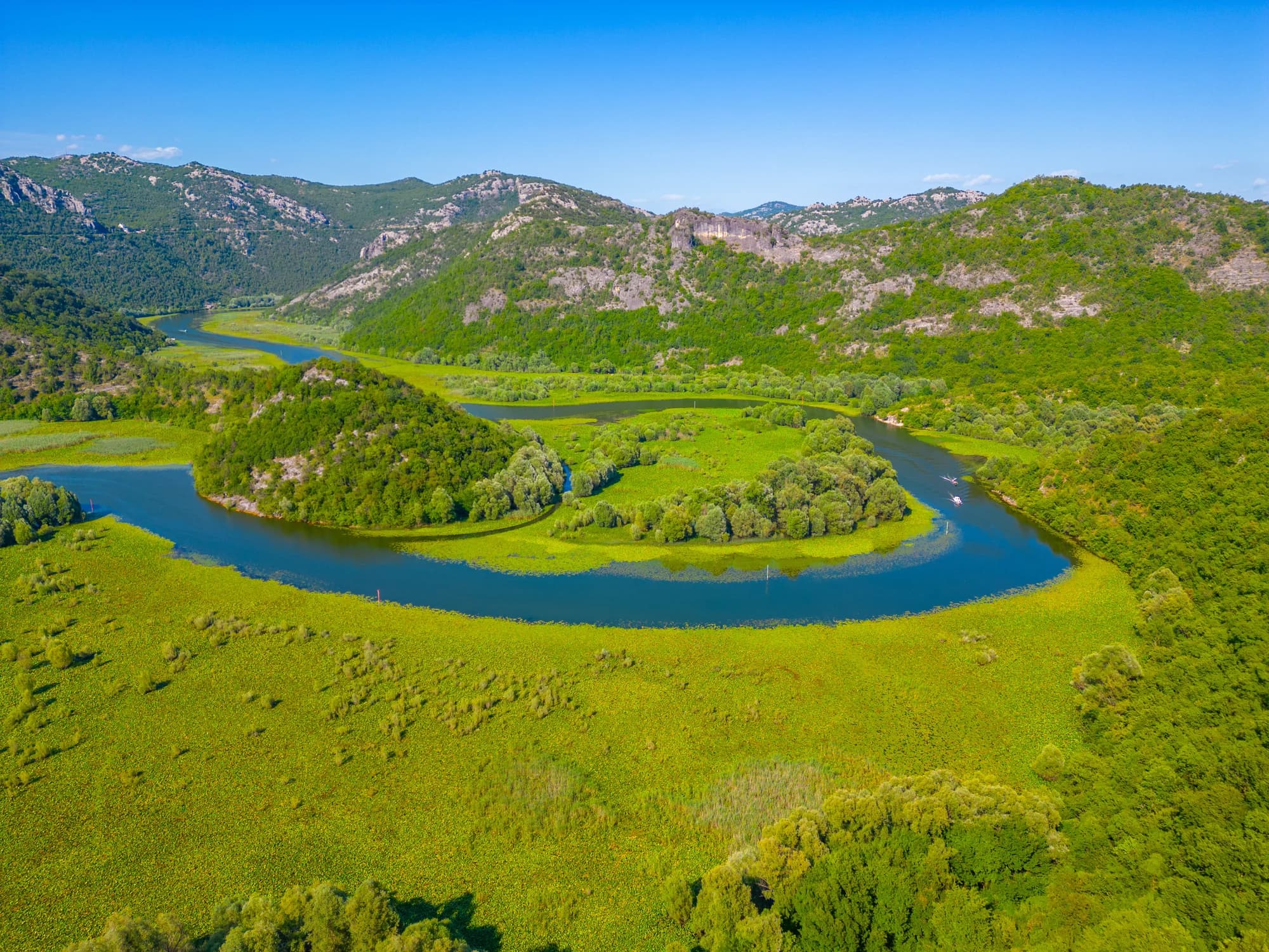
Der Flussarm bei Rijeka Crnojevića