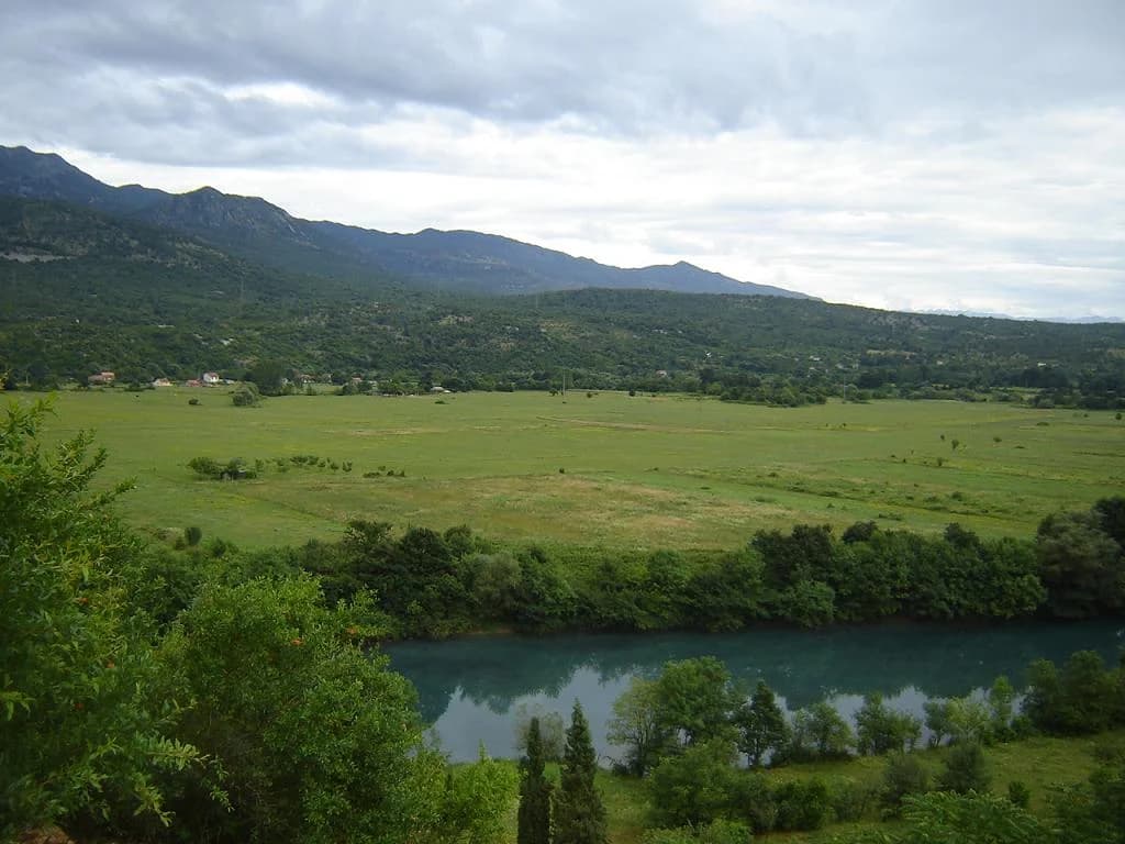
The Bjelopavlići plain is not an empty green interval between Montenegro's capital and its second city. It is a settled, cultivated river landscape in which the Zeta, farms, roads, railway, religious sites and protected habitats compete for the same narrow lowland. Danilovgrad gives the plain an urban centre, but the destination only makes sense when visitors read the river system and working land around it—not when they treat every field, bank and monastery as a ready-made attraction.

The plain at a glance
| Question | Evidence-backed answer | What remains local and changeable |
|---|---|---|
| What is it? | A broad central lowland organised around the lower Zeta | There is no single signed visitor boundary |
| Main base? | Danilovgrad for rail, services and a walkable centre | Outlying stops need separate transport |
| Why protect it? | River, habitats, landscape and sustainable local use | Protection does not make every bank recreational |
| Can visitors swim? | Only after checking an exact access and current local advice | Water quality, current, depth and ownership |
| Can visitors tour farms? | Only through a confirmed host or current operator | Season, work cycle, food service and payment |
| Best way to explore? | One defined route with a verified return | Heat, road traffic, surface and access notices |
The municipality's legacy geographic profile estimates the Bjelopavlići plain at about 160 square kilometres. Treat that as an orientation figure, not a surveyed tourism zone. The plain grades into settlements, river terraces and the slopes around it; the protected area follows its own legal boundary. Marketing language often uses “Zeta valley,” “Bjelopavlići plain” and “Danilovgrad” as if they were interchangeable. They are not: one describes a river system, one a landscape, and one a town and municipality.
This page is deliberately limited to the landscape. For broader municipal background, compare the long-form Danilovgrad guide and the shorter Danilovgrad overview; both are maintained independently and should be checked against current official notices. This guide asks a narrower question: what does the plain reveal when river ecology, agriculture and movement are considered together?

The Zeta is a system, not one scenic swimming hole
The national Water Administration's 2024 register gives the Zeta a total length of 73.31 kilometres, excluding the hydropower conduit. It separates an upper river of 21.74 kilometres from a lower river of 51.57 kilometres. The register describes the upper system as strongly regulated for the Perućica hydropower complex; the lower river runs mainly in a natural channel through Danilovgrad before meeting the Morača in Podgorica. That distinction matters because a photograph or condition report from one reach cannot safely describe the other.
The register also gives a 1,650-square-kilometre surface catchment and names the Gračanica and Sušica as principal tributaries. Those basin figures explain why local conditions depend on more than weather over the visible bank. Rain and infrastructure upstream, groundwater connections, abstraction and discharges can all matter. Visitors should therefore reject the easy visual equation “transparent water equals safe water.” Clarity is an appearance, not a microbiological result.

Protected status comes with an unresolved numbers problem
In 2019, national and local authorities declared the Zeta River and valley a nature park. The Government described the purpose in terms of biodiversity, habitats, landscape and sustainable development. Its Cabinet record reported an area of 119.85 square kilometres, divided 78% in Danilovgrad municipality and 22% in Podgorica. Those are the figures attached to the decision and protection study.
A current page from Podgorica's protected-areas agency gives a different total: 121.78 square kilometres, divided 80.8% and 19.2%. The page does not explain the change. It may reflect later mapping or a different administrative basis, but the material reviewed does not establish which. A responsible guide should not quietly choose the newer-looking number and erase the discrepancy. For legal boundaries, land use or property decisions, consult the managing authority and current official maps rather than either rounded summary.
| Source | Total area | Danilovgrad share | Podgorica share | How to use it |
|---|---|---|---|---|
| Government Cabinet record, 2019 | 119.85 km² | 78% | 22% | Historical decision and study figures |
| Podgorica protected-areas agency, accessed 2026 | 121.78 km² | 80.8% | 19.2% | Current agency profile; discrepancy unexplained |
Protection also does not erase environmental pressure. A 2021 government basin plan identified inadequate wastewater treatment in Danilovgrad as a pressure on the relevant Zeta water body. That is an important dated diagnosis, not proof that the same condition persists unchanged in 2026. This research did not locate a current official bathing-water bulletin for a specific river access. The safe editorial conclusion is limited: do not infer cleanliness from protected status, an old planning document or an archive image.
How to approach a riverbank responsibly
Choose an exact access before setting out. Ask the park manager, municipal tourism contact or a responsible local host whether the bank is public, currently used and appropriate for the intended activity. Check recent rain, current, depth, entry and exit, shade, fire restrictions and mobile coverage. A family picnic, a swim, a paddle and an angling trip have different legal and safety requirements; one generic “river spot” cannot answer all four.
- For swimming: seek current local water and safety advice; never treat a calm surface as evidence of depth or weak current.
- For children: maintain direct supervision and identify the exit before entry; archive images do not show underwater hazards.
- For fishing: confirm the current permit, season, protected species and exact zone with the competent body.
- For paddling: verify put-in, take-out, water level, obstacles and private boundaries with a current operator or local authority.
- For picnics: use established access, keep vehicles off soft banks, avoid fire and carry all waste out.
Do not cross a field because a map shows the river beyond it. The plain is densely used and much of its visual openness is private or productive land. Gates, irrigation equipment, animals and farm traffic are not scenic props. Drone use adds privacy, safety and aviation questions that should be resolved before launch, especially around homes, infrastructure and religious sites.
Agriculture is a working economy, not a tasting-room stereotype
An older national biodiversity strategy identifies the Zeta–Bjelopavlići area as one of Montenegro's agro-ecological regions and associates it with vegetables, field crops and fruit, including grapes. The classification is useful at regional scale, but it cannot tell a visitor what a particular field contains today. Crop choice, livestock, irrigation, market conditions and household income change; a landscape article should not convert regional potential into a claim that every lane leads to wine and homemade rakija.
Current policy work points to soil as a live issue rather than a timeless gift. In 2026, the Ministry of Agriculture reported an ECOBASE survey of producers in Danilovgrad and three neighbouring municipalities as part of work on soil health and land degradation. A survey announcement does not establish results for this plain, but it does show the questions officials are asking: how land is managed, what pressures producers face and which practices can protect soil.
Visitors can support the rural economy without inventing intimacy. Book through a current, identifiable host; ask what is actually being offered; and agree on time, price, language and payment. For food, ask about ingredients, allergens and preparation rather than accepting “natural” or “homemade” as a safety standard. For alcohol, designate a driver and never assume an informal tasting is unlimited. The Montenegro wine guide explains grapes and tasting decisions at national scale without assigning every Bjelopavlići property to a wine route.

Danilovgrad is the anchor, not the whole landscape
The town gives visitors a railway station, services and a compact place to begin. MONSTAT counted 18,617 usual residents in the municipality in the 2023 census; that number must not be relabelled as the urban population. Many sites carrying a Danilovgrad address are dispersed through the municipality and require their own last-mile plan.
The centre's planned street pattern and cultural institutions deserve attention, but repeating their full history here would blur the editorial cluster. Use the comprehensive report for the Art Colony, Local Museum, nineteenth-century planning and Adžija Bridge conservation. For this landscape itinerary, the town's function is simpler: orient, confirm conditions, obtain supplies without relying on a remote village shop, and set a realistic return time.

Getting there: rail works for the centre; the plain still needs a route
The railway operator's live timetable lists local services through Danilovgrad between Podgorica and Nikšić. Rail can make a town-centre visit car-free, and the line itself demonstrates how the valley functions as a movement corridor. This article omits departure times and fares because a durable guide should send readers to the official timetable near the travel date.
A station arrival does not solve river access, rural appointments or slope routes. Before accepting a taxi quotation, specify the exact place, waiting time, return and payment method. Drivers should verify current road and parking conditions rather than treating an online estimate as a guarantee. The broader Montenegro transport guide helps compare car, bus and transfer trade-offs; the Podgorica accommodation guide helps travellers who want a larger base.
Cycling demands more caution than the plain's flat centre suggests. The National Tourism Organisation's Top Trail 4 brochure routes through Danilovgrad and toward Prekornica, introducing significant climbing and exposure beyond the lowland. It is evidence of a promoted corridor, not live navigation. Because the brochure is old, verify surface, marking, traffic and water locally; carry lights and offline navigation; and avoid the hottest hours. A railway return should be confirmed before committing to a one-way ride.
The religious landscape rises above the plain
Ostrog is visible as a different kind of relationship between lowland and cliff. Its upper complex is built into the rock, while the lower complex occupies a separate level. Both are active religious places, not scenic extensions of a river drive. The landscape view can explain why the site dominates the valley without reducing pilgrims or worship to a photograph.

Plan the monastery as one deliberate stop. Dress appropriately for worship, silence phones, avoid photographing people in prayer and follow monastic or police directions. Major observances can transform road conditions. The researched Ostrog guide covers access and interpretation in detail; the pilgrimage guide addresses religious etiquette across the country.

Two defensible ways to explore
Car-free: town and one confirmed river access
Check the live railway schedule in both directions, then arrive in Danilovgrad with enough margin to miss a planned return. Walk the centre and obtain current local advice before choosing any riverbank. Use a confirmed taxi only if the access is beyond a comfortable walking route. Keep the day focused: a centre walk, one safe river perspective and a meal are more credible than an itinerary that claims monasteries, farms and swimming without transport.
By car: landscape transect with one appointment
Begin in town, cross the plain on a defined public route and make one pre-arranged stop—farm, guided outdoor activity or religious site. Do not build the day around unconfirmed businesses copied from old articles. Carry water, avoid parking on agricultural access and turn back from an unsigned rough road before it becomes a rescue problem. Continue toward Nikšić only if daylight and the onward plan remain sound; the Nikšić guide should be treated as a separate destination decision.
Season, heat and river conditions
| Period | Landscape opportunity | Main risk | Planning response |
|---|---|---|---|
| March–May | Green lowland and cooler walking | Rain, changing river levels and May pilgrimage traffic | Check water and road notices |
| June | Long daylight | Fast-rising heat and exposed cycling | Start early and carry water |
| July–August | Long operating day | Heat, fire risk and pressure at river access | Protect midday; never assume swimming safety |
| September–October | Field activity and milder travel | Private work areas and shorter days | Use booked hosts; preserve return margin |
| November–February | Quiet views and civic rhythm | Wet surfaces, high water and limited hours | Keep a town-based alternative |
The old page declared late spring and early autumn “ideal,” but no season is universally best. A photographer, cyclist, swimmer, pilgrim and farm guest need different conditions. During the summer peak, use the high-season planning guide to protect time and avoid crowd assumptions. During wet weather, view the river from a safe established crossing or public space rather than testing an unknown bank.
Accessibility and family decisions
This research found no current, route-level accessibility audit for the plain. Central Danilovgrad is comparatively level, but kerbs, surfaces, station access, toilets and continuous step-free paths must be checked individually. A flat-looking farm lane may be loose, muddy or blocked; a riverbank may have steep drops; the monastery complex has substantial vertical and crowd constraints.
Ask providers for measurements and surfaces, not the word “accessible.” Families should ask about shade, barriers, toilets, animals, road crossings and the exact distance back to transport. Heat exposure can make a short route unsuitable. The most responsible plan may be a town-centre visit and an arranged viewpoint rather than a river descent.
Frequently asked questions
Is the Bjelopavlići plain the same as Danilovgrad?
No. Danilovgrad is the main town and a municipality; the plain is a wider physical and cultural landscape. Some attractions marketed with the town name are far outside the walkable centre.
How large is the plain?
A legacy municipal profile gives an approximate area of 160 square kilometres. Use it for scale, not as a legal or navigational boundary.
Is the Zeta safe for swimming?
This guide cannot certify that. Check an exact access, current local advice, water condition, current, depth, entry and exit. Nature-park status is not a bathing-water test.
Why do official park figures differ?
The 2019 Cabinet record and the current Podgorica protected-areas page publish different totals and shares, but the reviewed pages do not explain the discrepancy. The guide preserves both.
Can I visit by train?
Yes for central Danilovgrad if the live timetable fits. Riverbanks, farms and religious sites still require a separate last-mile plan.
Can I stop at any farm or vineyard?
No. Productive land is not automatically visitor space. Arrange a visit with a current host and confirm the activity, time, price, allergens and payment before arrival.
Sources and methodology
Research was completed on 26 August 2026. It prioritised national water and protection records, the current protected-areas profile, agriculture material, MONSTAT, the railway operator, the national tourism body and the municipal archive. Claims are narrowed to the date and geography each source supports. No visit, interview, water test, farm inspection, route survey or accessibility audit is claimed.
Seven allowlisted archive images were downloaded, opened and visually reviewed. They document the lower-river landscape, central Danilovgrad and the Ostrog complex; captions explicitly separate visual evidence from current access and safety. The hydrology graphic reproduces official 2024 lengths.
- Water Administration 2024 register
- Government nature-park declaration
- Government 2019 Cabinet park figures
- Podgorica protected-areas agency park profile
- Government Adriatic-basin water-management plan
- National biodiversity strategy
- Ministry ECOBASE soil-health survey
- Railway Transport of Montenegro timetable
- National Tourism Organisation Top Trail 4 brochure
- Municipality geographic archive
- MONSTAT final 2023 census release