
Morinj
En 165 meter lang stripe med sand og grå småstein i hjørnet av bukten der en kald bekk kommer ut av karsten, med to campingplasser bak og mølle-restauranten ovenfor veien.
Vår dom
Morinj er det eneste stedet i Risan-bassenget med noe som ligner en strand: OpenStreetMap merker den som sand, oversikten kaller den grå småstein i en skyggefull, skogkledd sving, og begge er enige om at den er rolig og grunn — familiebadet i denne enden av bukten. Kildene under overflaten holder vannet kaldt ved bekkemunningene hele sommeren, som er poenget i august. Adgangen er gratis, solsenger koster noen få euro i sesongen, Kamp Naluka ligger ved elvemunningen, og Ćatovića Mlini ligger i møllehagen ovenfor veien.
Morinj i fakta
Stranden
Fasiliteter
Adkomst
Regler og karakter
Fakta verifisert 28. september 2026 · Lengde: OpenStreetMap way 1278875855 "Plaža Morinj (3A)", about 165 m along the shore; no official length published · 11 opplysninger gjenstår å sjekke på stedet
Morinj i bilder
Noen av disse er våre og kan gjenbrukes fritt under CC BY 4.0; resten er lisensiert og kan ikke. Våre er tatt i september 2026.
Kart
Det skraverte vannet er den offisielle badesonen for målestasjon Morinj 01 — strekningen JP Morsko dobro faktisk tar prøver av, ikke omrisset av stranden.
Slik kommer du dit
10 km
Herceg Novi
11 km
Tivat airport
12 km
Kotor
Avstander i luftlinje — veiene i Montenegro er fjellveier, så kjøreturen er lengre.
- Med bussStops with shelters on the M-1 shore road through the village (OpenStreetMap); route names not verified
- Med bilOn the M-1 at the north-west corner of the bay: Risan 5.9 km, the Kamenari ferry 5.5 km, Herceg Novi 20 km; paid parking about €4 a day by the beach, free spaces 200–500 m away
- 2 min til fotsflatt — From the shore-road parking across to the pebbles where the stream comes in
I dag på Morinj
Retningen er regnet ut fra OpenStreetMap-kystlinjen, så pålands- og fralandsvind gjelder denne stranden og ikke regionen. Værvarsel fra Open-Meteo
Vann og utmerkelser
Utmerket
Siste offisielle prøve 28. september 2026: Utmerket
Sjøen 20.2 °C da prøven ble tatt
6 av 10 prøver utmerket i sesongen 2026
Offisielt resultat fra JP Morsko dobro, målestasjon Morinj 01
Klart grønt vann ved bryggen; kildekaldt ved bekkemunningene hele sommeren. Ingen Morsko Dobro-resultat foreligger for denne sektoren
Ingen utmerkelse vi kan dokumentere for denne stranden. Det er også informasjon.
Godt å vite før du bader
- Vannet ved bekkemunningene holder seg kaldt hele sommeren — kildene kommer opp under overflaten — så gå sakte uti, spesielt barn
- En bøyelinje merker badeområdet i sesongen; utenfor den bruker båter bryggen og campingplassens fortøyninger
- M-1-veien går mellom campingplassene og kysten — kryss med forsiktighet
- Den betalte parkeringsplassen (om lag €4 dagen) fylles i juli og august; de gratis plassene ligger 200–500 m unna
Når vannet er varmt
Morinj var varmest, 25.8 °C, den 31. august 2026, og kaldest, 16.8 °C, den 25. mai 2026. Hvert punkt er en faktisk prøvetaking med temperaturen målt på stedet, ikke et månedsgjennomsnitt hentet et annet sted fra.
Åpne punkter er de 4 prøvetakingene som kom tilbake under «Utmerket».
Se alle 10 prøvetakingene
| Prøvetatt | Sjø | Resultat |
|---|---|---|
| 28. september 2026 | 20.2 °C | Utmerket |
| 14. september 2026 | 22.4 °C | Tilfredsstillende |
| 31. august 2026 | 25.8 °C | Utmerket |
| 17. august 2026 | 24.8 °C | God |
| 3. august 2026 | 23.1 °C | Utmerket |
| 23. juli 2026 | 22.0 °C | Tilfredsstillende |
| 8. juli 2026 | 19.2 °C | Utmerket |
| 22. juni 2026 | 24.0 °C | God |
| 8. juni 2026 | 17.0 °C | Utmerket |
| 25. mai 2026 | 16.8 °C | Utmerket |
Offisielt resultat fra JP Morsko dobro, målestasjon Morinj 01
Sesong for sesong
Morinj er prøvetatt 69 ganger siden 2020: 40 av målingene utmerket, 29 under det.
Hvor varmt vannet ble, sesong for sesong. Snittet gjelder bare prøvene i juli og august — et fast vindu, slik at et år inspektørene kom tidlig ikke framstår som kaldt.
En håndfull sesonger er en oversikt, ikke en trend: spredningen her er slik få daterte målinger ser ut, ikke bevis for et hav som blir varmere eller kaldere. Et hult punkt markerer en sesong der en prøve havnet under utmerket.
| Sesong | Prøver | Utmerket | Under | Snitt juli–aug. | Varmest |
|---|---|---|---|---|---|
| 2020 | 9 | 8 | 1 | 24.6 °C | 26.6 °C |
| 2021 | 10 | 7 | 3 | 22.2 °C | 25.2 °C |
| 2022 | 10 | 7 | 3 | 23.8 °C | 25 °C |
| 2023 | 10 | 2 | 8 | 20.4 °C | 22.9 °C |
| 2024 | 10 | 4 | 6 | 23.4 °C | 26 °C |
| 2025 | 10 | 6 | 4 | 21.2 °C | 23.2 °C |
| 2026pågår | 10 | 6 | 4 | 23 °C | 25.8 °C |
Offisielt resultat fra JP Morsko dobro, målestasjon Morinj 01
Tildelt som
Staten leier ut denne kysten parsell for parsell. Morinj er lyst ut som 2 parseller på rundt 135 m strandlinje, hver med en offisiell kategori.
| Kategori | Parseller | Strandlinje |
|---|---|---|
| Familiebading | 2 | 135 m |
Til sammen rundt 1,803 m². Dette er hva som er tildelt, ikke hva vi så: antall solsenger, toaletter og dusjer per parsell fastsettes i den signerte avtalen, som ikke offentliggjøres. Anbud fra JP Morsko dobro
Strender i nærheten



Morinj og nabostrendene
De samme ni målene for strendene du rekker samme dag. Fet skrift betyr at det skiller seg fra denne.
| Mål | Morinjdenne stranden |  Lipci1.3 km Lipci1.3 km |  Risan4.5 km Risan4.5 km |  Stoliv5.1 km Stoliv5.1 km |
|---|---|---|---|---|
| Underlag | sand og fin rullestein | rullestein — skiller seg | rullestein — skiller seg | betongplattformer — skiller seg |
| Nedgang i vannet | slak | steinete — skiller seg | moderat — skiller seg | bratt — skiller seg |
| Dybde | grunt | blir raskt dypt — skiller seg | blir raskt dypt — skiller seg | dypt fra kanten — skiller seg |
| Skygge | trær og parasoller | ingen — skiller seg | ingen — skiller seg | ingen — skiller seg |
| Karakter | tilrettelagte og frie deler | vill — skiller seg | vill — skiller seg | vill — skiller seg |
| Lengde | 165 m | 20–50 m — skiller seg | 200 m | 100 m — skiller seg |
| Siste prøve | Utmerket | —ingen offisiell målestasjon — skiller seg | Utmerket | Utmerket |
| Folkemengde | ro | ro | ro | ro |
| Slik kommer du dit | med bil | med bil | til fots — skiller seg | med bil |
Bo nær Morinj
All overnatting i Morinj →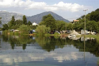
Spørsmål
- Er Morinj-stranden sand eller småstein?
- Begge deler, avhengig av hvem du spør: OpenStreetMap merker sektoren som sand, vår oversikt og strandkatalogen beskriver grå småstein. Luftfotoet viser en lys, fin kyst — forvent fin grus og sand snarere enn en ren sandstrand.
- Hvorfor er vannet så kaldt?
- Ferskvannskilder kommer opp under overflaten der bekken fra møllene når bukten, og de holder vannet der kaldt hele sommeren. Selve bukten når om lag 25 °C i august; bekkemunningene gjør det ikke.
- Kan jeg campe ved Morinj?
- Ja: Autocamp Naluka ligger ved siden av stranden ved elvemunningen, med drikkevann og wifi kartlagt, og Autocamp Đule og Auto Kamp Lara ligger om lag 1 km østover langs kystveien.
- Hva koster det?
- Adgangen er gratis. Solsenger koster om lag €4–8 hver fra juni til september, og parkeringsplassen ved stranden om lag €4 dagen, med gratis plasser 200–500 m unna.
Kilder
- montenegro.com — Morinj hub (/cities/morinj) and its source notes (traveltomontenegro.com Morinj beach page; mojaavantura.com distances)
- OpenStreetMap — beach way 1278875855 "Plaža Morinj (3A)", relation 17546484 "3B", campsite way 177389658 and nodes 4353804489, 4987897521, parking way 177389661, sheltered bus stops on the M-1
- montenegro.com — Lipci hub source notes (Morinj: Plaža Morinj, Autocamp Naluka, Autocamp Đule, a shop, Ćatovića Mlini)