
Risan
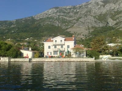
Steinviker på begge sider av havnen i den eldste byen ved bukta, med Orjen-toppene speilet i det flate vannet og en romersk mosaikk av søvnguden 300 m fra kysten.
Vår dom
Risan er et bad mellom to andre ting: gulvene i den romerske villaen med Hypnos-mosaikken, og en kaffe på kystveien. Badingen er beskjeden — stein- og betongflekker på begge sider av havnen snarere enn en strand — men vannet i bunnen av bukten er rolig, fjellene reiser seg rett opp av det, og nesten ingen andre er i vannet. Kom i mai, juni eller september, når mosaikkene er dine alene.
- svømming
- ro
- fotografering
Risan i fakta
Stranden
Fasiliteter
Adkomst
Fakta verifisert 28. september 2026 · Lengde: Our 25 Best Beaches list; the OpenStreetMap beach polygon west of the harbour (way 240080159) also runs about 200 m · Fasiliteter fra OpenStreetMap contributors, ODbL · 13 opplysninger gjenstår å sjekke på stedet
Risan i bilder
Noen av disse er våre og kan gjenbrukes fritt under CC BY 4.0; resten er lisensiert og kan ikke.
Kart
Det skraverte vannet er den offisielle badesonen for målestasjon RISAN — strekningen JP Morsko dobro faktisk tar prøver av, ikke omrisset av stranden.
Slik kommer du dit
12 km
Kotor
13 km
Tivat airport
14 km
Herceg Novi
Avstander i luftlinje — veiene i Montenegro er fjellveier, så kjøreturen er lengre.
- Med bussStops with shelters on the M-1 shore road through the town (OpenStreetMap); Kotor local buses run Kotor–Perast–Risan — route names not verified
- Med bilOn the M-1 shore road at the head of the bay, 17.5 km from Kotor (about 20 minutes) and 3 km beyond Perast; park in the town
- 3 min til fotsflatt — Along the waterfront from the centre of Risan; the coves lie either side of the harbour
I dag på Risan
Retningen er regnet ut fra OpenStreetMap-kystlinjen, så pålands- og fralandsvind gjelder denne stranden og ikke regionen. Værvarsel fra Open-Meteo
Vann og utmerkelser
Utmerket
Siste offisielle prøve 28. september 2026: Utmerket
Sjøen 20.5 °C da prøven ble tatt
10 av 10 prøver utmerket i sesongen 2026
Offisielt resultat fra JP Morsko dobro, målestasjon RISAN
Bunnen av bukten: flatt, skjermet vann med Orjen-toppene speilet i det; ingen Morsko Dobro-resultat foreligger for Risan
Ingen utmerkelse vi kan dokumentere for denne stranden. Det er også informasjon.
Godt å vite før du bader
- Betongkanter og trapper snarere enn en skrånende kyst: pass på barna ved vannkanten
- Båter som bruker havnen og bryggekonobaene deler vannet med badende
- M-1-kystveien går langs vannkanten; vikene nås ved å krysse den
Når vannet er varmt
Risan var varmest, 27.5 °C, den 31. august 2026, og kaldest, 20.0 °C, den 25. mai 2026. Hvert punkt er en faktisk prøvetaking med temperaturen målt på stedet, ikke et månedsgjennomsnitt hentet et annet sted fra.
Se alle 10 prøvetakingene
| Prøvetatt | Sjø | Resultat |
|---|---|---|
| 28. september 2026 | 20.5 °C | Utmerket |
| 14. september 2026 | 24.7 °C | Utmerket |
| 31. august 2026 | 27.5 °C | Utmerket |
| 17. august 2026 | 25.4 °C | Utmerket |
| 3. august 2026 | 25.2 °C | Utmerket |
| 20. juli 2026 | 26.7 °C | Utmerket |
| 6. juli 2026 | 21.9 °C | Utmerket |
| 22. juni 2026 | 24.1 °C | Utmerket |
| 8. juni 2026 | 22.6 °C | Utmerket |
| 25. mai 2026 | 20.0 °C | Utmerket |
Sesong for sesong
Risan er prøvetatt 30 ganger siden 2024: 22 av målingene utmerket, 8 under det.
| Sesong | Prøver | Utmerket | Under | Snitt juli–aug. | Varmest |
|---|---|---|---|---|---|
| 2024 | 10 | 6 | 4 | 25.1 °C | 27.7 °C |
| 2025 | 10 | 6 | 4 | 24.3 °C | 25.6 °C |
| 2026pågår | 10 | 10 | — | 25.3 °C | 27.5 °C |
Tildelt som
Staten leier ut denne kysten parsell for parsell. Risan er lyst ut som 3 parseller på rundt 254 m strandlinje, hver med en offisiell kategori.
| Kategori | Parseller | Strandlinje |
|---|---|---|
| Familiebading | 3 | 254 m |
Til sammen rundt 3,010 m². Dette er hva som er tildelt, ikke hva vi så: antall solsenger, toaletter og dusjer per parsell fastsettes i den signerte avtalen, som ikke offentliggjøres. Anbud fra JP Morsko dobro
Strender i nærheten



Risan og nabostrendene
De samme ni målene for strendene du rekker samme dag. Fet skrift betyr at det skiller seg fra denne.
| Mål | Risandenne stranden |  Lipci3.3 km Lipci3.3 km |  Bajova Kula5.0 km Bajova Kula5.0 km |  Orahovac6.1 km Orahovac6.1 km |
|---|---|---|---|---|
| Underlag | rullestein | rullestein | rullestein | rullestein |
| Nedgang i vannet | moderat | steinete — skiller seg | moderat | moderat |
| Dybde | blir raskt dypt | blir raskt dypt | blir raskt dypt | blir raskt dypt |
| Skygge | ingen | ingen | naturlig — skiller seg | naturlig — skiller seg |
| Karakter | vill | vill | tilrettelagt — skiller seg | vill |
| Lengde | 200 m | 20–50 m — skiller seg | 118 m — skiller seg | 150 m |
| Siste prøve | Utmerket | —ingen offisiell målestasjon — skiller seg | Utmerket | Utmerket |
| Folkemengde | ro | ro | ro | ro |
| Slik kommer du dit | til fots | med bil — skiller seg | med bil — skiller seg | med bil — skiller seg |

Spørsmål
- Hvor bader folk egentlig ved Risan?
- Fra steinvikene på begge sider av havnen ved vannkanten, nådd ved å krysse kystveien. OpenStreetMap kartlegger en 200 m lang stripe rett vest for havnen og en mindre «Pomodna plaža» 600 m sør mot Perast.
- Kan jeg kombinere badet med mosaikkene?
- Lett: den romerske villaen ligger i byen, noen få minutter til fots fra kysten. Dra dit før turistbussene ankommer; oversikten anbefaler mai og juni for å ha gulvene for deg selv.
- Ligger Risan på en bussrute?
- M-1-kystveien går gjennom byen og har holdeplasser med leskur; Kotors lokalbusser når Risan via Perast (om lag 20 minutter fra Kotor langs veien). Rutenavn er ikke bekreftet for denne siden.
Kilder
- montenegro.com — Risan hub (/cities/risan)
- Our "25 Best Beaches in Montenegro" list, entry 25
- OpenStreetMap — beach ways 240080159, 240248810, 240248980, 240248981, 239301386 "Pomodna plaža"; café node 4353492290; town node 425487395 (Nominatim); sheltered bus stops on the M-1