The story
A weapon made of three buildings
Arza is the least visited and least photographed fortification in this series, and the reason is simple: you cannot get in. It is also the one that makes least sense on its own, because it was never designed to work alone.
Between 1850 and 1854 Austria-Hungary built three forts to close the entrance to the Bay of Kotor: Oštro on the Prevlaka peninsula, now in Croatia; Mamula on the island of Lastavica; and Arza on the cape at the south-western tip of Luštica. The strait they cover is a little over two kilometres wide. The guns on Luštica threw 150 mm shells about ten and a half kilometres, and 210 mm mortars answered from Cape Oštro.
The point was never the individual fort. It was the geometry: three positions whose fields of fire crossed over the only navigable entrance, so that a ship running the gap was under fire from three directions at once and could not silence any one of them without exposing itself to the other two. In the First World War all three were hit, which is the system working as designed.
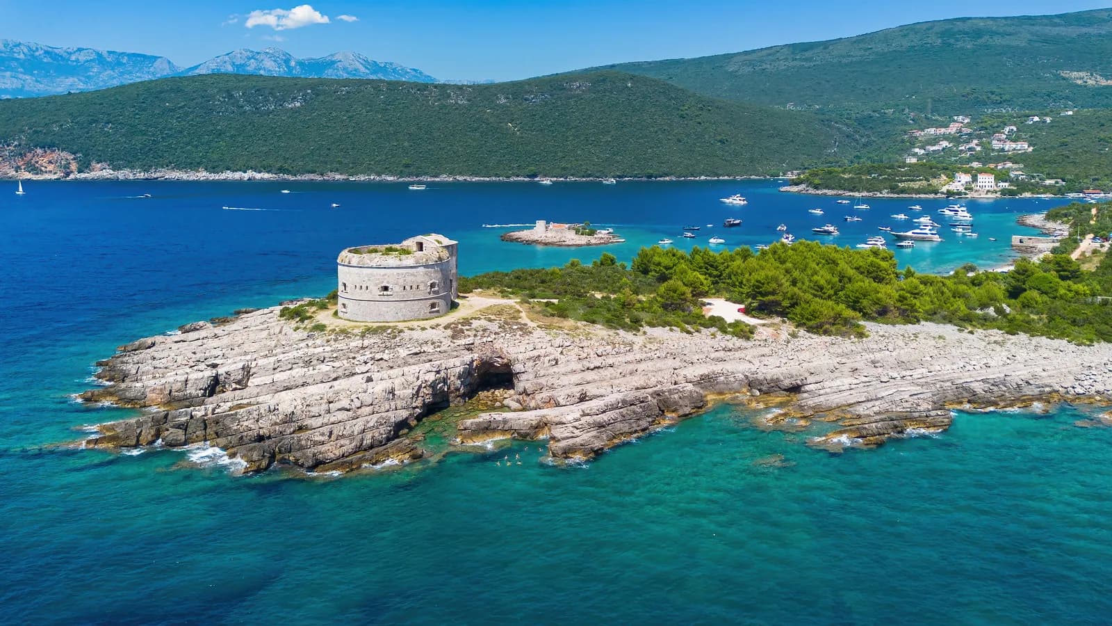
- The fort itself. A squat masonry tower on the tip of the cape, open-topped now. It never needed to be large: Mamula and Oštro were each doing a third of the work, and ninety-two men and two officers were the entire garrison.
- The gun embrasures. The row of dark slots around the seaward face. Each one is a gun position covering the water, and their spacing is the whole design brief — every degree of the approach had to be covered by something.
- The cape. Bare limestone, shelving straight into deep water. The fort is on the tip because that is the furthest point out: every hundred metres of headland is a hundred metres more of the strait covered.
- The water it was aimed at. The strait between Luštica and Prevlaka is a little over two kilometres wide. The 150 mm guns on this side reached about ten and a half kilometres, and 210 mm mortars answered from Cape Oštro opposite.
- Boats at anchor. The same water the batteries were built to close is now one of the busiest anchorages on the coast. Arza is the only fort of the three you still cannot enter.
2009 – today
The only one you cannot enter
Empire ended, the guns went, and Arza sat empty on its headland for most of a century. In 2009 it was sold for €4.5 million to a Russian, Montenegrin and Serbian consortium, which announced a tourist complex reported at €100 million. That complex has not been built.
What exists instead is a locked, privately owned fort about five hundred metres’ walk from the beach at Mirište, decaying quietly, described by people who have tried as the only fortress in Montenegro that is locked. Mamula went one way — leased, restored, reopened at five stars, argued about. Arza went the other: bought, announced, and left.
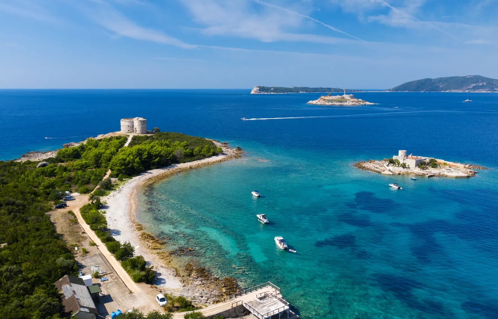
Two thirds of a gate, in one frame
This is the argument of the whole article in a single photograph. Arza is the round fort on the headland at the left. The fortified island in the middle distance, with the lighthouse on it, is Mamula. The third fort, Oštro, sits out of frame on the Prevlaka peninsula beyond.
The water between them is the only navigable way into the Bay of Kotor. Built between 1850 and 1854, the three forts covered it from three directions at once, so a ship running the gap could not silence one without exposing itself to the other two. Seen from the ground, Arza is a small ruin on a cape. Seen from here, it is one gun of three.
The forts also show you what happened next. Mamula was leased, restored and reopened in 2023 as a five-star hotel, argued about the whole way. Arza was bought in 2009, announced as a €100 million resort, and left locked. Same strait, same decade of construction, opposite endings.
1850 → today
The full timeline
Dated events only. Where sources disagree, the conflict is stated in the entry rather than resolved silently.
Austro-Hungarian
1850–19181850–1854
The three forts of the first line
Oštro, Mamula and Arza, closing the entrance to the Bay of Kotor. Sources date Arza itself to about 1850, or more loosely to the second half of the 19th century.
19th c.
Guns and garrison
150 mm guns on Luštica with a range of about 10.5 km, 210 mm mortars from Cape Oštro. Arza holds 92 soldiers and two officers.
1914–18
All three forts are hit
Mamula, Arza and Oštro are all struck during the attacks on the bay entrance.
Yugoslav & Montenegrin
1918–200920th c.
Emptied
The fort loses its purpose along with the rest of the line and stands empty on the cape.
Private ownership
2009–today2009
Sold for €4.5 million
To a Russian, Montenegrin and Serbian consortium, which announces a tourist complex reported at €100 million.
today
Locked
The complex has not been built. The fort is private and closed — about 500 m on foot from Mirište beach, and no further.
Corrections
What the internet gets wrong
These claims circulate widely online and do not survive checking. If you have read about Arza elsewhere, you have probably met at least one of them.
Not public
Arza is private property and locked.
Several listings present it as a visitable ruin. It was sold in 2009 and is closed. You can walk to the outside from Mirište; that is all.
Dates differ
“About 1850”, or “the second half of the 19th century”.
Herceg Novi’s inventory gives around 1850; other accounts date it more loosely. The construction of the three-fort line between 1850 and 1854 is the firmer fact.
Often omitted
Oštro is in Croatia.
The third fort of the line sits on the Prevlaka peninsula, which is Croatian territory. A description of the bay’s defences that stops at the border describes two thirds of a system.
Sources and image record
Dates and interpretations are tied to the archive and research sources below. Where they conflict, the conflict is named in the text rather than smoothed over.
- Opština Herceg Novi — Znamenitosti
The municipal inventory of the fortress system, with dates, dimensions and functions
- Opština Herceg Novi — The history
Sovereignty timeline; 1979 earthquake damage across the fortresses
- Plan (archaeology) — the phasing convention
The colour-by-period phase plan this page’s visual system borrows
- IMG Mamula — Istorijat
The 1850–54 construction of Oštro, Mamula and Arza as the first line of defence
- Alexandre ROSA — Cape of Arza (Adobe Stock 908303694)
Licensed stock photograph · the aerial view of the fort on its cape
- TATIANA — Arza and Mamula (Adobe Stock 383592434)
Licensed stock photograph · Arza and Mamula across the strait
- Balkan Insight — Forgotten Forts
The condition and ownership of Austro-Hungarian fortifications in Montenegro, including the 2009 sale