The story
The one that did not survive
Five fortifications ring Herceg Novi and four of them are still standing. This is the fifth. The Citadela closed the southern end of the medieval defensive system, on the shore below the Old Town, eight metres above the water, and on 15 April 1979 it stopped existing.
It went by three names. Citadela is the modern one. In the older records it is Macel, and it is also Mezzaluna — the crescent — which describes the shape: semi-circular to polygonal, with gun positions looking straight out at the water, a cistern inside and a guard post.
Its job was to complete Forte Mare. One fort stood above the entrance to the bay; this one sat on the water at the southern tip of the promontory. Herceg Novi’s heritage literature says that under Venetian rule, at the end of the seventeenth century, the two of them made a single defensive system. Neither was designed to work alone.
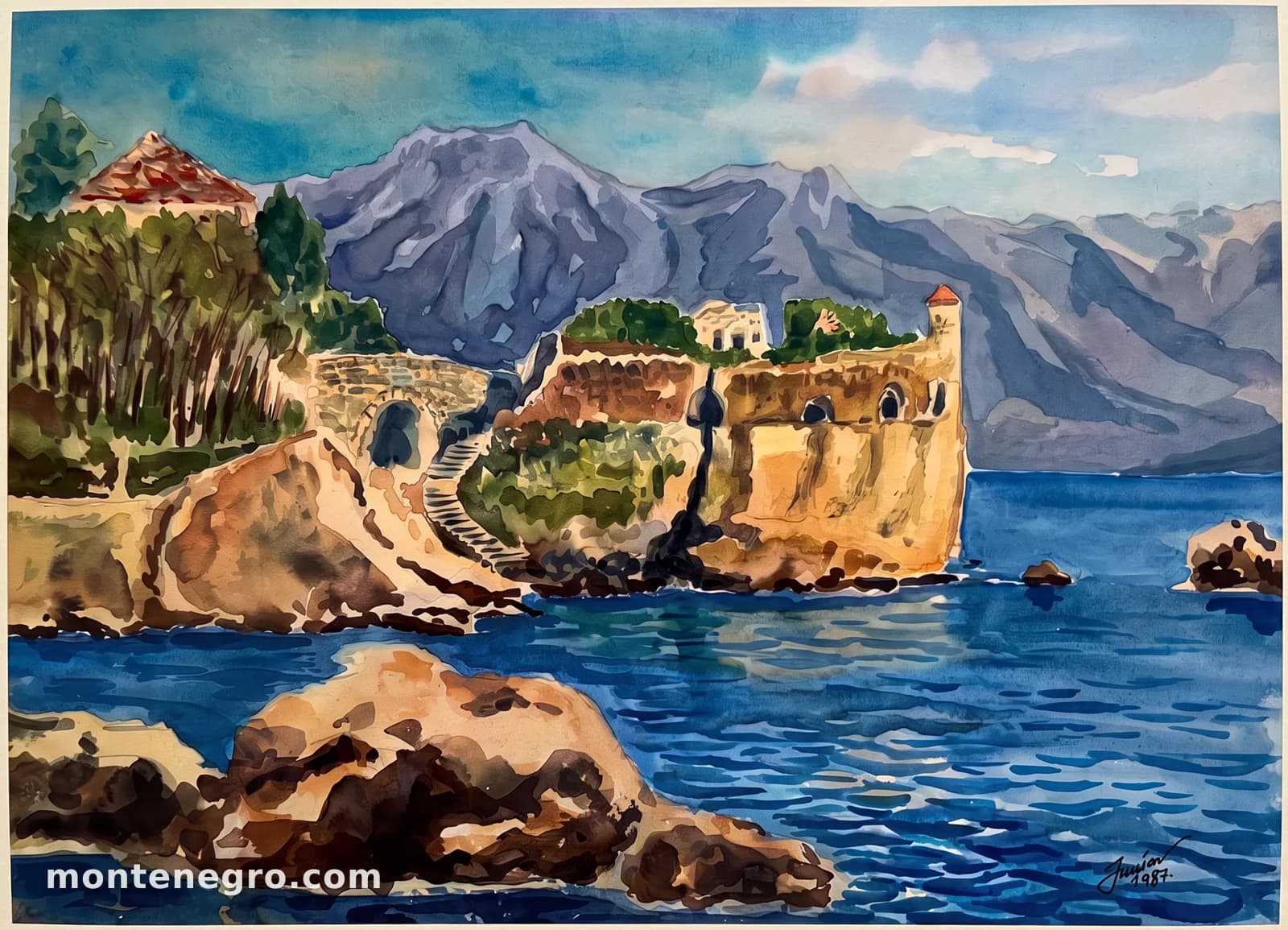
- The guns, facing the water. The arched openings in the seaward face. The heritage surveys describe the Citadela as semi-circular to polygonal with gun positions onto the sea — this is the only picture in the series that shows them in a standing building.
- Where the wall met the sea. The municipal inventory puts it plainly: its southern walls were in the sea. The fortification sat about eight metres above the water at the southern tip of the medieval defensive system.
- The bridge and the stair. The arch on the left, with steps climbing past it. A fortified wall ran from here to the Lower Town, carried over what is now the Šetalište pet Danica promenade on a stone bridge.
- The turret. The small tower with the red roof, above the main mass. No source available here dates it, so it carries the neutral colour rather than a phase — the painting records it, the record does not explain it.
- None of this is there. On 15 April 1979 the younger walls of the Citadela overturned completely. Everything in this picture above the rock line is gone. What remains is one consolidated stretch of wall and a scatter of stone in the water.
15 April 1979
Ninety seconds
The Montenegro earthquake damaged Forte Mare, cracked Kanli Kula and shook every fortification on this coast. The Citadela it destroyed. The heritage account does not soften it: after the earthquake, complete overturning of the younger walls occurred.
It has never been rebuilt. In 2017 a conservation workshop consolidated the surviving western wall, cleared the vegetation and repaired the walkways — that is stabilisation of a ruin, not restoration of a fortress, and the distinction matters.
The comparison with Forte Mare is the useful one. Forte Mare was rebuilt from a 1984 project that heritage scholarship criticises for smoothing six centuries of phases into one uniform masonry. The Citadela got no such treatment, and the result is that the most honest surviving evidence of the Herceg Novi defences is the pile nobody tidied.
The stone is still there. It is simply in the water now.
What survives of the Citadela, visible from the wall of Forte Mare
Reading the pair
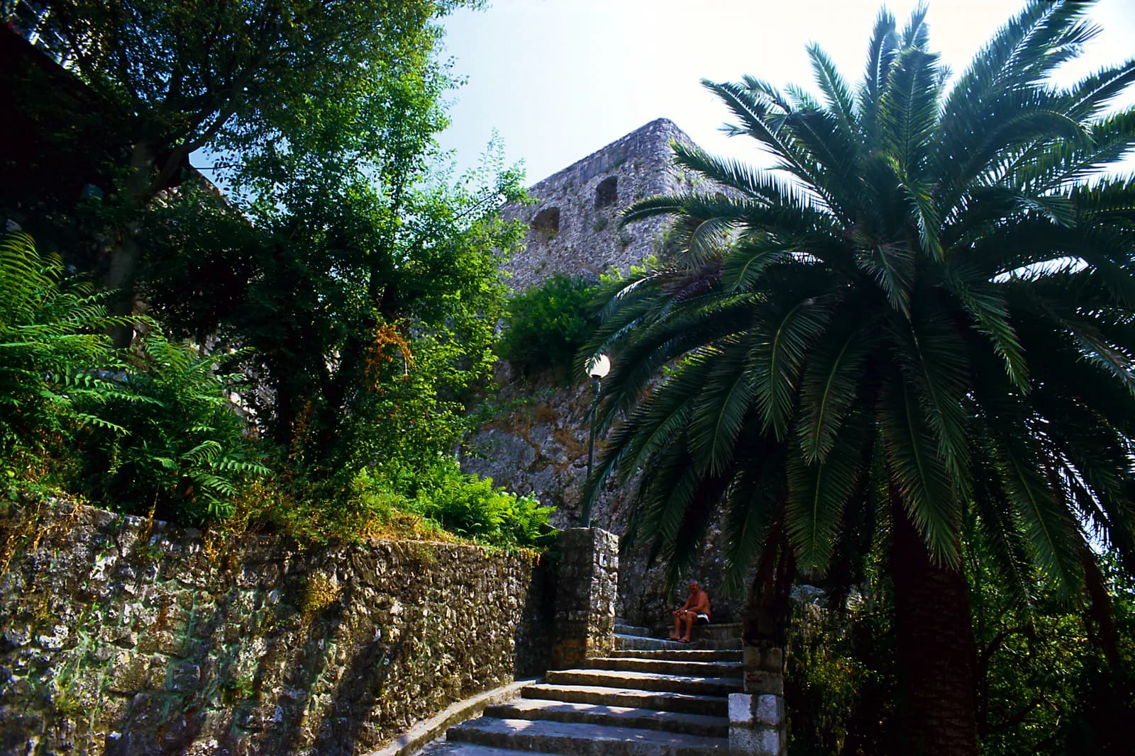
The painting above is the fortress; the photograph beside this is the site. That is the whole comparison, and there is no version of it that is not bleak.
The watercolour is signed and dated 1987 — eight years after the earthquake. It is therefore not a picture painted from life before the collapse, but a reconstruction of a building that had already gone, made from memory or from earlier images. That does not make it less useful. For a fortification whose origin was never firmly dated and which no longer stands, a careful painting of what it looked like is close to the best evidence available.
The photograph is filed on Wikimedia Commons as the Zitadelle at Herceg Novi and shows masonry pierced by two openings of the kind the surveys describe as gun positions facing the sea. That identification is the photographer's, not ours, which is why it is stated rather than assumed. Set against the painting, it gives you the measure of what 1979 took: a fortress, reduced to a wall behind a palm tree.
15th → today
The full timeline
Dated events only. Where sources disagree, the conflict is stated in the entry rather than resolved silently.
Uncertain origin
15th century?15th c.?
A core of undetermined date
Herceg Novi’s heritage literature states the time of origin has not been reliably established; a 15th-century date is presumed, possibly under Herceg Stjepan Vukčić Kosača.
Ottoman
1482–16871482–1687
Two centuries in the Ottoman system
The fortification serves through the Ottoman period at the southern edge of the defences.
Venetian
1687–1797late 17th c.
The crescent takes its form
Semi-circular to polygonal, 8 m above the sea, gun positions facing the water, a cistern and a guard post. With Forte Mare it forms a single defensive system.
1702
Linked to the Lower Town
A fortified wall, carried on a stone bridge above what is now Šetalište pet Danica, ties the Citadela to the town.
Austro-Hungarian
1814–191819th c.
Still in service, then not
The fortification is used through the Austro-Hungarian period and then loses its purpose along with the rest of the system.
Yugoslav & Montenegrin
1918–today15 Apr 1979
The Montenegro earthquake
Complete overturning of the younger walls. The Citadela is the one element of the Herceg Novi defensive system that does not survive.
2017
A conservation workshop
The western wall is consolidated, vegetation cleared and walkways repaired. Stabilisation, not reconstruction.
today
Stone on the shore and in the sea
Visible from the wall of Forte Mare. There is no ticket, no gate and no building to enter.
Corrections
What the internet gets wrong
These claims circulate widely online and do not survive checking. If you have read about Citadela elsewhere, you have probably met at least one of them.
Widely repeated
“Built in 1702.”
1702 is the date of the wall and bridge that connected the Citadela to the Lower Town, not of the fortification itself. The heritage survey is explicit that the origin date has never been established.
Not restored
The 2017 work was stabilisation.
A conservation workshop consolidated the western wall and cleared vegetation. Nothing was rebuilt, and no reconstruction is under way.
Check before you go
There is nothing to visit.
This is a ruin at the waterline beside a public promenade, not an attraction. The best view of what remains is from the wall of Forte Mare, looking down.
Sources and image record
Dates and interpretations are tied to the archive and research sources below. Where they conflict, the conflict is named in the text rather than smoothed over.
- Opština Herceg Novi — Znamenitosti
The municipal inventory of the fortress system, with dates, dimensions and functions
- Opština Herceg Novi — The history
Sovereignty timeline; 1979 earthquake damage across the fortresses
- Plan (archaeology) — the phasing convention
The colour-by-period phase plan this page’s visual system borrows
- Citadela, Macel, Mezzaluna — prošlost koja nestaje
The heritage account: undated origin, the crescent form, 8 m elevation, the 1979 collapse and the 2017 workshop
- Watercolour of the Citadela, signed 1987 — montenegro.com collection
The fortification as it stood, painted eight years after it fell. Reproduced by permission
- Wikimedia Commons — Zitadelle Herceg Novi
Falk2 · CC BY-SA 4.0 · the photograph, with the photographer’s identification