The story
Not a ring. A climb.
Almost every fortified town in this series solved the same problem the same way: a wall around the houses and a fort on the high ground. Kotor did something else. Its wall leaves the water and keeps going — up a cliff, for 260 vertical metres, until it reaches the summit and stops.
The result is four and a half kilometres of fortification, climbed today by about 1,350 steps, wrapping a mountainside rather than a settlement. Seen from the bay it reads less like a defence than a ribbon laid across the rock. It is the largest fortification in Montenegro by a wide margin, and the only one in this series inside a UNESCO World Heritage property.
It was not built by anyone in particular. The fortifications went up between the ninth and the nineteenth centuries and are usually described as a blend of Illyrian, Byzantine, Venetian and Austrian military architecture — four civilisations, each adding to what it found. Venice, which held the town from 1420 to 1797, did most of it.
When the ring closed
One detail is worth holding on to, because it undercuts the postcard. The walls did not actually form a continuous ring around the Old Town until the thirteenth or fourteenth century. For most of its early life this was not a sealed circuit but an accumulation of positions — a hilltop, a fortress, stretches of wall — that only later got joined into the single object visitors now walk.
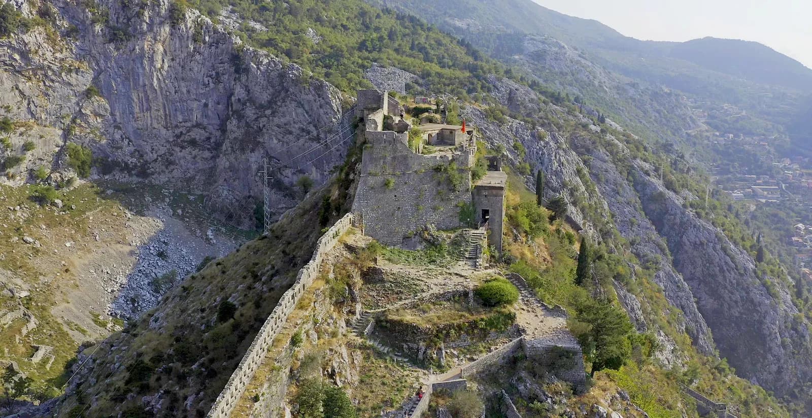
- The summit works. The buildings on the highest ground, where the Byzantine fortress stood and where the climb ends. Everything below this point was built to get people up to it, or to stop them.
- The curtain down the ridge. The crenellated wall running along the spine of the rock. This is the Venetian work that makes up most of the 4.5 kilometres, and it does not stop until it reaches the town on the shore.
- The steps. About 1,350 of them, switchbacking up roughly 260 vertical metres. The path and the wall are the same piece of engineering: the climb is the fortification.
- The cliff that did the work. No wall was ever needed on this side. The fortifications only exist where the mountain stops being a defence on its own — which is why the circuit is a ribbon rather than a ring.
- What it was watching. The valley and the inner bay, far below. Everything the walls were built to see is in this frame, and so is the reason UNESCO inscribed the whole region rather than the town alone.
1667 and 1979
Shaken down twice
Two earthquakes define what stands. The great earthquake of 1667 devastated Kotor, as it devastated Dubrovnik and much of this coast; everything below the summit has been repaired at least once because of it.
The second was on 15 April 1979 — the same shock that destroyed the Citadela at Herceg Novi and cracked Forte Mare. In Kotor it seriously damaged a large number of monuments, including four Romanesque churches and the town walls themselves.
That is worth setting beside Herceg Novi. The same earthquake, forty kilometres apart, produced two opposite outcomes: Kotor was rebuilt with international help and is now a World Heritage town; the Citadela was never rebuilt at all and is stone in the water. What decides which fortification survives is rarely the fortification.
Today
The most climbed wall in the country
San Giovanni is the busiest fortification in Montenegro. There is a ticket, a path, and in high summer a queue on the lower steps. The route passes the Church of Our Lady of Remedy about halfway up and ends at the fortress on the summit, with the whole inner bay laid out below.
Sources differ on the height — 260 metres is the figure most often given for the fortress, some say 280 — and on almost everything else about the early phases. What is not in dispute is the shape of the thing: a thousand years of people deciding that this rock was worth the walk.
to 6 → today
The full timeline
Dated events only. Where sources disagree, the conflict is stated in the entry rather than resolved silently.
Illyrian & Roman
to the 6th centurypre-Roman
An Illyrian fortification on the height
Accounts place the first fortification of the hilltop above present-day Kotor in the Illyrian period.
168 BC
Roman construction begins on the site
Byzantine
6th–12th century6th c.
A Byzantine fortress on the summit
The height above the town is fortified in the Byzantine period; its work sits at the top of the modern climb.
Serbian & local rule
12th century–142013th–14th c.
The circuit finally closes
The walls do not form a continuous ring around the Old Town until this period. Before it, the defences are an accumulation of separate positions.
Venetian
1420–17971420
Kotor passes to Venice
The town becomes Cattaro and stays Venetian for 377 years.
15th–18th c.
The bulk of what stands
4.5 km of wall, from the shore to the summit at about 260 m, climbed today by roughly 1,350 steps.
1667
The great earthquake
Kotor is devastated along with much of the coast; the walls below the summit are repaired.
1797
The Venetian Republic falls
Austro-Hungarian
1814–191819th c.
An Austrian garrison on a Venetian line
Barracks and batteries are added along the existing fortifications rather than replacing them.
Yugoslav & Montenegrin
1918–today15 Apr 1979
The Montenegro earthquake
Four Romanesque churches and the town walls are seriously damaged.
1979
Inscribed by UNESCO — and listed in danger
The Natural and Culturo-Historical Region of Kotor joins the World Heritage list and the List of World Heritage in Danger in the same year, because of the earthquake.
2003
Removed from the danger list
After 24 years of post-earthquake conservation.
today
About 1,350 steps, and a ticket
The busiest fortification in Montenegro, and the only one in this series inside a World Heritage property.
Corrections
What the internet gets wrong
These claims circulate widely online and do not survive checking. If you have read about San Giovanni elsewhere, you have probably met at least one of them.
Often muddled
The walls were not always a ring.
A continuous circuit around the Old Town only existed from the 13th or 14th century. Descriptions that treat the whole system as one medieval build skip about a thousand years of accumulation.
Figures differ
260 metres, or 280.
Both heights are widely published for San Giovanni. The step count is usually given as about 1,350, and the wall length as 4.5 km — all of these are round figures, not survey data.
Widely missed
Kotor was listed and endangered in the same year.
1979 brought both the UNESCO inscription and, because of the April earthquake, immediate placement on the List of World Heritage in Danger. It took until 2003 to come off. Most summaries mention only the inscription.
Sources and image record
Dates and interpretations are tied to the archive and research sources below. Where they conflict, the conflict is named in the text rather than smoothed over.
- UNESCO — Natural and Culturo-Historical Region of Kotor
The inscription, the property boundary and the conservation record
- Wikipedia — Natural and Culturo-Historical Region of Kotor
1979 inscription with simultaneous danger listing; removal in 2003
- Wikipedia — Fortifications of Kotor
Construction between the 9th and 19th centuries; the Illyrian, Byzantine, Venetian and Austrian layers
- Visit Montenegro — San Giovanni Fortress
The climb, the step count and the fortress on the summit
- TATIANA — Kotor fortress (Adobe Stock 435629547)
Licensed stock photograph · the aerial of San Giovanni on its ridge
- Plan (archaeology) — the phasing convention
The colour-by-period phase plan this page’s visual system borrows