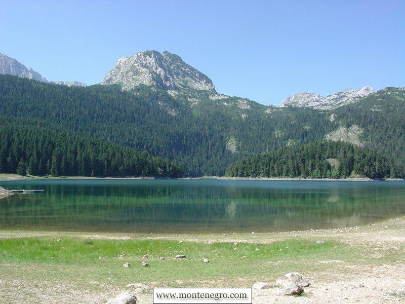
Fifteen reader photographs arrived as a “Durmitor photo record.” The first showed Black Lake. The next two showed Biogradsko Lake—inside a different national park, on a different mountain massif. That small archival mistake offers a better story than a generic gallery: northern Montenegro is not one interchangeable landscape, and every lake, forest and high pasture makes more sense when it is put back in the right protected area.
The photographs were contributed by Igor Samac of Tivat. Their files carry no reliable shoot date, coordinates or camera metadata, so they are not evidence of current trail, snow or ice conditions. They are historical observations. This reconstruction keeps that character while checking place names, elevations, park boundaries, visitor fees and conservation claims against current official sources.
Two parks, one archive
| Feature | Protected area | Published figure | How to read it |
|---|---|---|---|
| Black Lake | Durmitor National Park | 1,416 m elevation | Two basins joined by a narrow channel; level changes seasonally |
| Durmitor World Heritage property | Durmitor National Park | 32,100 ha | UNESCO boundary, not every broader tourism-area figure |
| Marked Durmitor trail network | Durmitor National Park | 25 trails; about 150 km | Difficulty and field condition vary |
| Biogradsko Lake | Biogradska Gora National Park | 1,094 m elevation | On Bjelasica, not Durmitor |
| Biogradsko Lake at high water | Biogradska Gora National Park | 228,500 m²; 3.3 km shoreline; 12 m max depth | Seasonal high-water dimensions |
| Daily park entry | Durmitor / Biogradska Gora | €5 / €4 | Current published rates; recheck before travel |
Durmitor is a limestone massif in the Dinaric Alps. UNESCO describes roughly fifty peaks above 2,000 metres, glacial lakes, alpine meadows, forests and the canyons of the Tara, Sušica, Draga and Komarnica. Biogradska Gora lies on Bjelasica, a more rounded, water-rich massif whose official park history emphasizes glacial forms, old forest and high pastures. The visual rhyme—green lake, forest, mountain—does not make them the same place.
For a complete trip base, use our Žabljak and Durmitor guide. For the other park, the Biogradsko Lake guide covers access from the Kolašin side. Combining both can be rewarding, but it should be planned as a two-park journey rather than a single lakeside walk.
| Park | Landscape | Marked trails | Scale |
|---|---|---|---|
| Durmitor | Limestone massif · Black Lake | 25 marked trails · ~150 km | UNESCO property · 32,100 ha |
| Biogradska Gora | Bjelasica · old forest · lake | 6 marked mountain trails | Biogradsko Lake · 1,094 m |
UNESCO Durmitor property record; National Parks of Montenegro Durmitor and Biogradska Gora visitor data. A photo sequence is not a map: check the park, route and conditions before moving.
Frames 1–3: the lake switch
Black Lake is Durmitor's most recognizable threshold. The official park description says its Great and Small basins are connected by a narrow flow and sit at 1,416 metres. Forest and the faces of Međed, Savin Kuk and Crvena Greda shape the familiar view. The lake is accessible enough to draw large numbers, but it is also part of a protected hydrological system, not a scenic reservoir arranged for recreation.
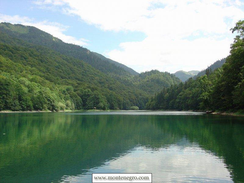
The next frame leaves Durmitor. Biogradsko Lake sits at 1,094 metres in the central part of Biogradska Gora. At high water, the park publishes a surface area of 228,500 square metres, an 875-metre length, a 410-metre maximum width, a 3,300-metre shoreline and a maximum depth of 12 metres. Those figures describe a high-water condition; they are not fixed dimensions through every dry or wet season.
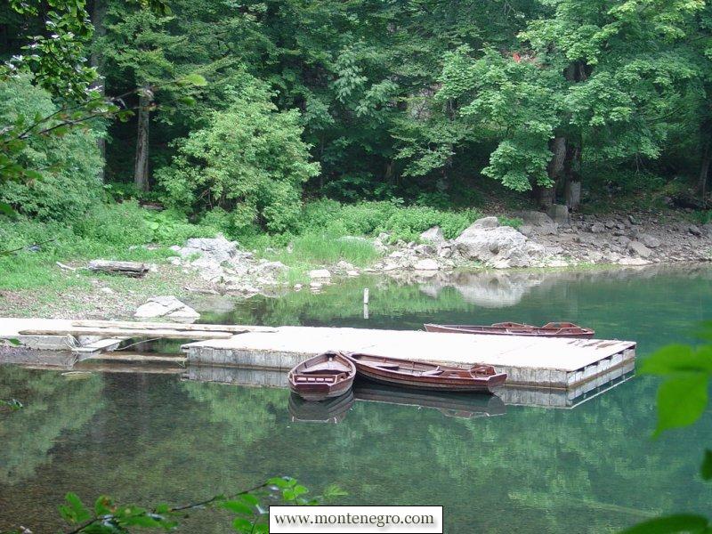
The third photograph shows small wooden boats on exceptionally clear water. The image is observational rather than current service information. The park's present price page lists boat rental at €10 an hour and kayak rental separately, but equipment, water level and operating hours can change. Verify on the official page rather than reading a legacy boat photograph as a promise.
Frames 4–8: forest is infrastructure
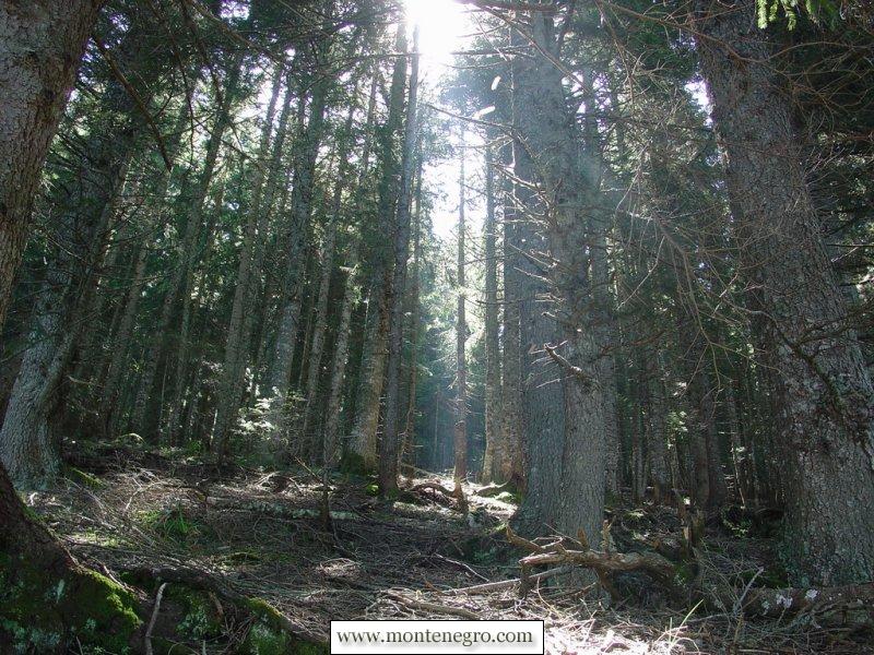
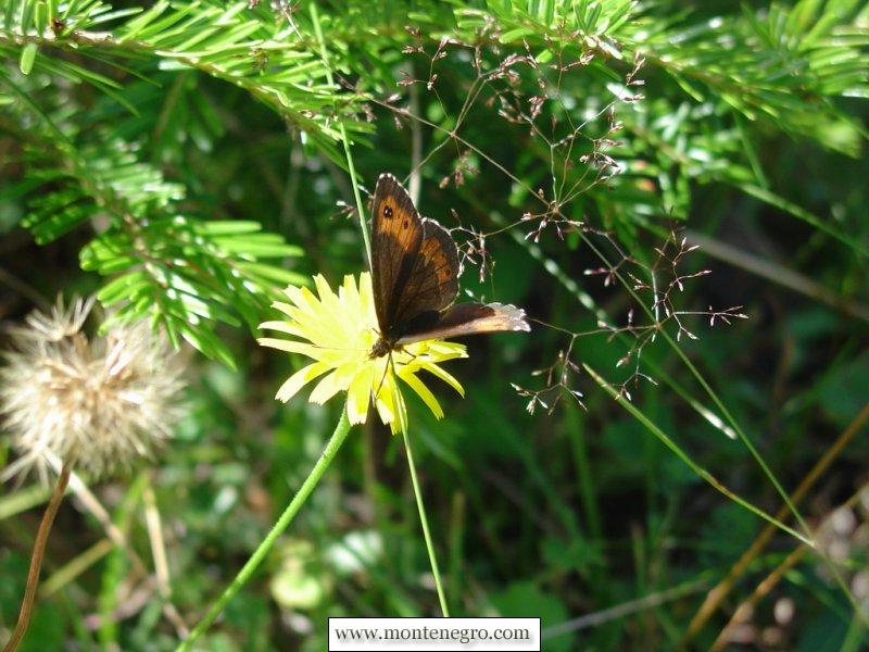
Durmitor's forest is not merely foreground for the peaks. UNESCO highlights a rare old-growth stand of European black pine and more than 1,600 vascular plant species across the wider massif. Large predators and 130 recorded bird species are part of the same system. A close-up butterfly photograph can suggest that diversity, but it cannot identify a species reliably without diagnostic detail and location data.
Biogradska Gora's official ecology pages describe about 2,000 plant species and subspecies across the park, including roughly 400 Balkan endemics, and a 1,600-hectare old-growth forest zone around the lake and Biogradska River canyon. These are institutional totals, not counts visible in the old photographs. The point is scale: a dark conifer aisle or small flower belongs to habitat networks that park management must protect from trampling, collecting, fire and unmanaged development.
Stay on marked surfaces around lake margins and in forest interiors. Do not collect flowers or mushrooms because a photograph makes them look abundant. The Biogradska Gora fee schedule lists permits for collecting forest fruits, mushrooms and medicinal or aromatic plants; that alone shows that casual harvesting is regulated rather than a free visitor activity.
Frames 9–10: Zminje Lake and connected water
The archive labels the green, shaded water as Zminje Lake. The national park's current route list connects Barno, Zminje and Black lakes, while another official account traces Mlinski Potok for about three kilometres from Zminje Lake to Black Lake. Fourteen watermills with around twenty wheels once worked along that stream, the park says, operating especially when spring and autumn flows were strongest.
That history is a useful correction to the idea of “untouched” scenery. Durmitor contains settlement, pasture, mills, paths and long resource use as well as wild systems. UNESCO's management statement explicitly calls for balance between conservation and legitimate local livelihoods. A lake can be ecologically valuable and culturally worked at the same time.
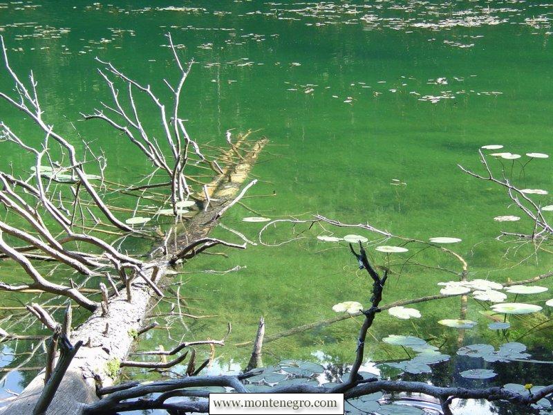
The 2025 park implementation report records amphibian monitoring at Zminje, Black and other glacial lakes and says the park decided to prohibit further fish stocking because the lakes lack native fish fauna and introductions could worsen ecological condition. That is a sharper current story than the old caption's “sun and shadows”: management is reconsidering what belongs in these mountain waters.
Frames 11–12: katun landscape and August weather
Two archive frames move above the forest: a small hut among pale limestone and a storm-darkened ridge with snow patches. The old captions identify Barske kolibe around 1,800 metres and emphasize that snow can remain in August. Because the files have no verified date or coordinates, this update does not use them to describe this summer's snowpack.
The broader cultural pattern is real. UNESCO notes that farmers and shepherds traditionally use high meadows as summer pasture. Katuns are working seasonal landscapes, not abandoned props. Visitors should treat huts, livestock, fences, water sources and hayfields as private or shared livelihood infrastructure. Ask before entering, photographing people at close range or moving anything.
Mountain weather changes the practical plan even on a bright morning. Carry insulation and rain protection, share a route, download an offline map and set a turnaround time. Montenegro's single emergency number is 112, but a number is useful only when a phone can connect and the caller can describe the location. Save coordinates and the last marked junction before trouble begins.
Frame 13: the Ice Cave is not a casual add-on
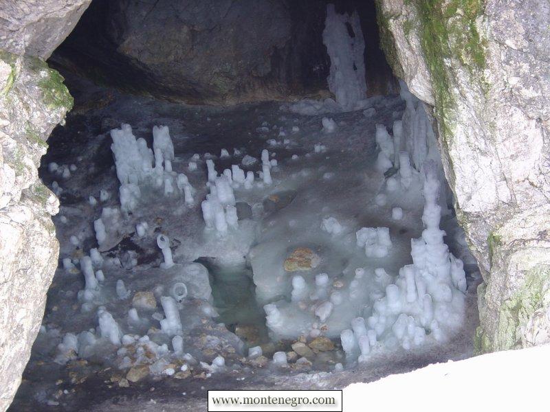
The Ice Cave below Obla Glava is a genuine Durmitor feature, highlighted in UNESCO's outstanding universal value and listed in the park's trail network. The 2026–2030 management plan includes a route from Žabljak through Lokvice to the cave and onward through high terrain. An official tourism page describes ice formations surviving through summer.
None of that makes entry routine. Conditions inside and on the approach depend on snow, ice, weather, navigation and equipment. The management plan says trail marking had been insufficient in the previous period and had caused orientation problems, especially for foreign visitors, even though staff have since received marker training. Treat the cave as a high-mountain objective, confirm the route with the park, and use a qualified guide if experience or current conditions demand it.
Frames 14–15: summit label, meadow finish
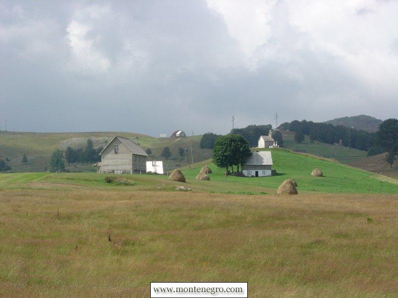
The penultimate image labels Obla Glava at 2,303 metres and points toward the Ice Cave. Because the annotation is embedded in a legacy photograph rather than a surveyed map, this article does not reproduce it as navigation. The last frame descends to haystacks and scattered huts; its old caption places the view near Meždo at about 1,360 metres.
That descent is the essay's strongest structure. Northern Montenegro is not a ladder from “civilization” to empty wilderness. Lake tourism, old forest, high routes, seasonal pasture and settlements overlap. The photograph of a meadow is therefore not an anticlimax. It shows the human landscape that conservation policy must include.
Practical choice: which park fits your day?
Choose Black Lake and Durmitor if the priority is dramatic limestone relief, a large trail network and a Žabljak base. The park publishes 25 marked mountain trails totalling about 150 kilometres, from the educational lake circuit to high routes toward Bobotov Kuk and the Ice Cave. “Marked” does not mean easy; compare distance, ascent, exposure and forecast rather than choosing by photograph. Our complete Žabljak guide helps with the town-side decisions that a park map does not cover.
Choose Biogradsko Lake if the priority is an old-forest lake setting and a shorter introduction that can expand into Bjelasica hiking. The park lists six marked mountain trails reaching lakes and high points such as Crna Glava, Troglava and Zekova Glava. For deeper context, see our Durmitor national-park guide and the separate Black Lake article.
The current official price pages list daily entry at €5 for Durmitor and €4 for Biogradska Gora. Durmitor boat rental is listed at €10 an hour; Biogradska Gora lists the same hourly boat rate and separate kayak options. Verify prices, opening status and equipment on the day. The old photos cannot answer operational questions.
What the sources say
A defensible one-day plan is deliberately modest. Pick one park, one primary route and a turnaround time; download the park map before leaving reliable reception; carry water, layers and footwear suited to wet roots or loose mountain ground; and tell somebody where you expect to finish. Keep the second lake or summit as an option, not an obligation. Conditions that look calm beside the car park can change rapidly with elevation. In an emergency, Montenegro's Ministry of Interior identifies 112 as the single emergency number, but a phone number is not a substitute for conservative route choice, location awareness or sufficient daylight.
Stay in Žabljak for early access to Durmitor; our Žabljak accommodation guide compares areas. First-time visitors fitting the north into a wider trip can use the seven-day Montenegro itinerary and the first-time visitor guide. These links solve logistics; the park sources remain authoritative for routes and rules.
The conservation story behind the view
Durmitor was inscribed on the World Heritage List in 1980 and its present UNESCO record gives a 32,100-hectare property. Other official tourism and historical documents publish 32,500, 34,000 or 39,000 hectares because boundaries, dates and denominators differ. The numbers should not be silently swapped. The World Heritage figure describes the inscribed property.
UNESCO's 2025 decision shows that recognition is not a finish line. The committee continued to address boundary alignment, tourism development and ski infrastructure, and requested an updated conservation report by 1 December 2026. A photo of a clear lake cannot measure those pressures. Reporting must pair beauty with the plans, boundaries and decisions that determine what survives.
Biogradska Gora faces a different management context, but the same principle applies. Its old forest is not protected by adjectives such as “primeval” alone. Trail maintenance, visitor behaviour, regulated collection, fire prevention, water monitoring and development control do the work. A responsible photo essay tells readers what they are seeing and what rules keep it visible.
Frequently asked questions
Are all these photographs from Durmitor?
No. The original sequence explicitly labels its second and third photographs as Biogradsko Lake in Biogradska Gora National Park. The restored title and captions make the two-park structure clear.
Is Black Lake 1,416 metres deep?
No. The figure is its elevation above sea level. The lake comprises two connected basins and its visible shoreline changes with water level.
Can beginners visit the Ice Cave alone?
Do not infer that from a photograph. It is a high-mountain route with navigation, weather, snow and cave-entry hazards. Check current park advice and use a qualified guide when experience or conditions require one.
How much is park entry?
The current official pages list €5 a day for Durmitor and €4 for Biogradska Gora. Treat those as checked August 2026 rates and verify before arrival.
Can I pick berries, flowers or mushrooms?
Do not assume so. Biogradska Gora's official fee schedule lists permits for collecting forest products, and protected-area rules apply. Leave wildflowers in place and ask park staff about any regulated collection.
What number should I call in an emergency?
Call 112 in Montenegro. Before hiking, also share the route, save offline mapping and record coordinates because mobile coverage may fail in mountain terrain.
Who took the original photographs?
The legacy article credits Igor Samac of Tivat. It does not provide a reliable shoot date, detailed route or coordinates, so the pictures are treated as a historical contribution rather than a current conditions report.